Lamie geodata
Lamie (Apulia) is a populated place; located in Italy in Europe/Rome (GMT+2) time zone. With population of 1,669 people, there are 4738 cities with bigger population in this country. Compared to other cities in Italy, 78.3% of cities are located further ↑North; 97.7% of cities are located further ←West and 69.2% of cities have higher elevation than Lamie. Note1


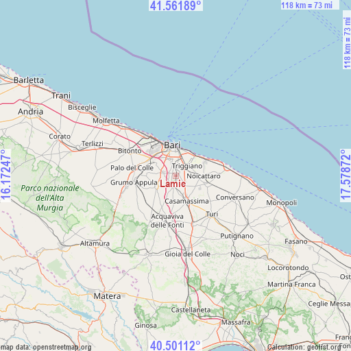
Lamie GPS coordinates[2]
41° 2' 1.104" North, 16° 52' 32.124" East
| Map corner | latitude | longitude |
|---|---|---|
| Upper-left | 41.56189°, | 16.17247° |
| Center: | 41.03364°, | 16.87559° |
| Lower-right: | 40.50112°, | 17.57872° |
| Map W x H: | 117.9×117.9 km | = 73.3×73.3mi |
| max Lat: | 47.04031° ⇑78.3% North |
| Lamie: | 41.03364° |
| min Lat: | ⇓21.7% South 35.50142° |
| min Long | Lamie | max Long |
| 6.69888° | 16.87559° | 18.48682° |
| W 97.7%⇐ | ⇒2.3% E |
Elevation
Elevation of Lamie is 102 m = 335 ft, and this is 204.7 m = 672 ft below average elevation for this country.
| Max E: |
2085 m = 6841 ft | 69.2% |
| Avg. | 306.7 m = 1006 ft | |
| Lamie | 102 m = 335 ft | |
Min E: |
-4 m = -13 ft | 30.8% |
See also: Italy elevation on elevation.city.
Geographical zone
Lamie is located in North temperate zone (between Tropic of Cancer and the Arctic Circle). Distance of this Northern Tropic circle is 1956.6 km =1215.8 mi to South.| Distance of | km | miles | from Lamie |
|---|---|---|---|
| North Pole | 5444.5 | 3383.1 | to North |
| Arctic Circle | 2838.7 | 1763.9 | to North |
| Tropic Cancer | 1956.6 | 1215.8 | to South |
| Equator | 4562.5 | 2835 | to South |


Nearby cities:
15 places around Lamie: (largest is in red/bold)
• Adelfia
3.4 km =2.1 mi,  184°
184°
• Bari
9.7 km =6 mi,  357°
357°
• Bitritto
4.2 km =2.6 mi,  284°
284°
• Capurso
4.1 km =2.5 mi,  70°
70°
• Casamassima
9.4 km =5.8 mi,  156°
156°
• Cellamare
4.6 km =2.9 mi,  109°
109°
• Loseto
2.4 km =1.5 mi,  293°
293°
• Modugno
9.6 km =6 mi,  306°
306°
• Noicattaro
9.6 km =6 mi,  89°
89°
• Parco Principi
6.5 km =4 mi, 155°
• San Pietro
4.6 km =2.9 mi,  51°
51°
• Sannicandro di Bari
7.5 km =4.7 mi,  240°
240°
• Superga
5.4 km =3.4 mi,  59°
59°
• Triggiano
5.5 km =3.4 mi, 49°
• Valenzano
1.4 km =0.9 mi,  34°
34°
Sources, notices
• [Note1] Compared only with cities in Italy existing in our database
• [Src1] Map data: © OpenStreetMap contributors (CC-BY-SA)
• [Src2] Other city data from geonames.org with taken over terms of usage.
• [Src3] Geographical zone / Annual Mean Temperature by Robert A. Rohde @ Wikipedia
