Cellamare geodata
Cellamare (Apulia) is a seat of a third-order administrative division; located in Italy in Europe/Rome (GMT+2) time zone. With population of 5,209 people, there are 1875 cities with bigger population in this country. Compared to other cities in Italy, 78.4% of cities are located further ↑North; 97.9% of cities are located further ←West and 67.8% of cities have higher elevation than Cellamare. Note1


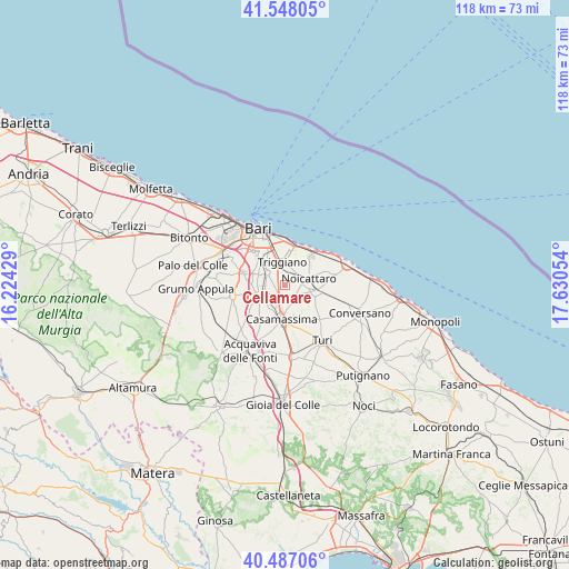
Cellamare GPS coordinates[2]
41° 1' 10.884" North, 16° 55' 38.676" East
| Map corner | latitude | longitude |
|---|---|---|
| Upper-left | 41.54805°, | 16.22429° |
| Center: | 41.01969°, | 16.92741° |
| Lower-right: | 40.48706°, | 17.63054° |
| Map W x H: | 118×118 km | = 73.3×73.3mi |
| max Lat: | 47.04031° ⇑78.4% North |
| Cellamare: | 41.01969° |
| min Lat: | ⇓21.6% South 35.50142° |
| min Long | Cellamare | max Long |
| 6.69888° | 16.92741° | 18.48682° |
| W 97.9%⇐ | ⇒2.1% E |
Elevation
Elevation of Cellamare is 110 m = 361 ft, and this is 196.7 m = 645 ft below average elevation for this country.
| Max E: |
2085 m = 6841 ft | 67.8% |
| Avg. | 306.7 m = 1006 ft | |
| Cellamare | 110 m = 361 ft | |
Min E: |
-4 m = -13 ft | 32.2% |
See also: Italy elevation on elevation.city.
Geographical zone
Cellamare is located in North temperate zone (between Tropic of Cancer and the Arctic Circle). Distance of this Northern Tropic circle is 1955 km =1214.8 mi to South.| Distance of | km | miles | from Cellamare |
|---|---|---|---|
| North Pole | 5446.1 | 3384 | to North |
| Arctic Circle | 2840.2 | 1764.8 | to North |
| Tropic Cancer | 1955 | 1214.8 | to South |
| Equator | 4561 | 2834.1 | to South |


Nearby cities:
15 places around Cellamare: (largest is in red/bold)
• Adelfia
5 km =3.1 mi,  248°
248°
• Bitritto
8.8 km =5.5 mi,  287°
287°
• Capurso
3 km =1.9 mi,  350°
350°
• Casamassima
7 km =4.3 mi,  184°
184°
• Lamie
4.6 km =2.9 mi, 289°
• Loseto
7 km =4.3 mi, 290°
• Noicattaro
5.5 km =3.4 mi,  72°
72°
• Parco Principi
4.7 km =2.9 mi,  200°
200°
• Parco Scizzo-Parchitello
8.2 km =5.1 mi,  42°
42°
• Rutigliano
6.6 km =4.1 mi,  99°
99°
• San Pietro
4.5 km =2.8 mi, 350°
• Sannicandro di Bari
11.1 km =6.9 mi,  258°
258°
• Superga
4.3 km =2.7 mi,  4°
4°
• Triggiano
5.1 km =3.2 mi,  357°
357°
• Valenzano
4.5 km =2.8 mi,  306°
306°
Sources, notices
• [Note1] Compared only with cities in Italy existing in our database
• [Src1] Map data: © OpenStreetMap contributors (CC-BY-SA)
• [Src2] Other city data from geonames.org with taken over terms of usage.
• [Src3] Geographical zone / Annual Mean Temperature by Robert A. Rohde @ Wikipedia
