Colleranesco geodata
Colleranesco (Abruzzo) is a populated place; located in Italy in Europe/Rome (GMT+2) time zone. With population of 1,432 people, there are 5287 cities with bigger population in this country. Compared to other cities in Italy, 65.1% of cities are located further ↑North; 77.8% of cities are located further ←West and 82.7% of cities have higher elevation than Colleranesco. Note1


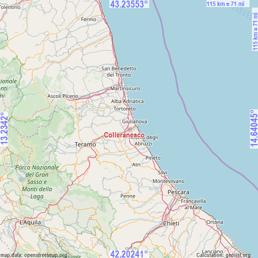
Colleranesco GPS coordinates[2]
42° 43' 16.032" North, 13° 56' 14.352" East
| Map corner | latitude | longitude |
|---|---|---|
| Upper-left | 43.23553°, | 13.2342° |
| Center: | 42.72112°, | 13.93732° |
| Lower-right: | 42.20241°, | 14.64045° |
| Map W x H: | 114.9×114.9 km | = 71.4×71.4mi |
| max Lat: | 47.04031° ⇑65.1% North |
| Colleranesco: | 42.72112° |
| min Lat: | ⇓34.9% South 35.50142° |
| min Long | Colleranesco | max Long |
| 6.69888° | 13.93732° | 18.48682° |
| W 77.8%⇐ | ⇒22.2% E |
Elevation
Elevation of Colleranesco is 39 m = 128 ft, and this is 267.7 m = 878 ft below average elevation for this country.
| Max E: |
2085 m = 6841 ft | 82.7% |
| Avg. | 306.7 m = 1006 ft | |
| Colleranesco | 39 m = 128 ft | |
Min E: |
-4 m = -13 ft | 17.3% |
See also: Italy elevation on elevation.city.
Geographical zone
Colleranesco is located in North temperate zone (between Tropic of Cancer and the Arctic Circle). Distance of this Northern Tropic circle is 2144.2 km =1332.3 mi to South.| Distance of | km | miles | from Colleranesco |
|---|---|---|---|
| North Pole | 5256.9 | 3266.5 | to North |
| Arctic Circle | 2651 | 1647.3 | to North |
| Tropic Cancer | 2144.2 | 1332.3 | to South |
| Equator | 4750.1 | 2951.6 | to South |


Nearby cities:
15 places around Colleranesco: (largest is in red/bold)
• Bellante Stazione
8.2 km =5.1 mi,  258°
258°
• Cologna Paese
3.1 km =1.9 mi,  161°
161°
• Cologna Spiaggia
3.7 km =2.3 mi,  89°
89°
• Giulianova
4.3 km =2.7 mi,  33°
33°
• Montepagano
6.5 km =4 mi,  139°
139°
• Morro d'Oro
6.6 km =4.1 mi,  191°
191°
• Mosciano Sant'Angelo
4.9 km =3 mi,  306°
306°
• Notaresco
7.9 km =4.9 mi,  206°
206°
• Petriccione
8.5 km =5.3 mi,  252°
252°
• Roseto degli Abruzzi
8.4 km =5.2 mi,  130°
130°
• Salino
7.4 km =4.6 mi,  345°
345°
• San Giovanni
8.5 km =5.3 mi,  151°
151°
• Santa Lucia
8.6 km =5.3 mi,  165°
165°
• Tortoreto Lido
8.7 km =5.4 mi,  2°
2°
• Villa Zaccheo
7.8 km =4.8 mi, 249°
Sources, notices
• [Note1] Compared only with cities in Italy existing in our database
• [Src1] Map data: © OpenStreetMap contributors (CC-BY-SA)
• [Src2] Other city data from geonames.org with taken over terms of usage.
• [Src3] Geographical zone / Annual Mean Temperature by Robert A. Rohde @ Wikipedia
