Rio Salso-Case Bernardi geodata
Rio Salso-Case Bernardi (The Marches) is a populated place; located in Italy in Europe/Rome (GMT+2) time zone. With population of 1,425 people, there are 5307 cities with bigger population in this country. Compared to other cities in Italy, 56.6% of cities are located further ↑North; 64.9% of cities are located further ←West and 73.3% of cities have higher elevation than Rio Salso-Case Bernardi. Note1
Administrative division(s):
- Level 1: The Marches
- Level 2: Provincia di Pesaro e Urbino
- Level 3: Tavullia
Current local time in Rio Salso-Case Bernardi:
05:36 PM, WednesdayDifference from your time zone: hours


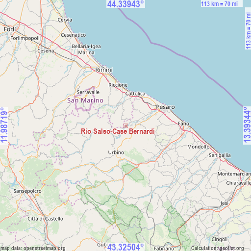
Rio Salso-Case Bernardi GPS coordinates[2]
43° 50' 3.804" North, 12° 41' 25.116" East
| Map corner | latitude | longitude |
|---|---|---|
| Upper-left | 44.33943°, | 11.98719° |
| Center: | 43.83439°, | 12.69031° |
| Lower-right: | 43.32504°, | 13.39344° |
| Map W x H: | 112.8×112.8 km | = 70.1×70.1mi |
| max Lat: | 47.04031° ⇑56.6% North |
| Rio Salso-Case Bernardi: | 43.83439° |
| min Lat: | ⇓43.4% South 35.50142° |
| min Long | Rio Salso-Case | max Long |
| 6.69888° | 12.69031° | 18.48682° |
| W 64.9%⇐ | ⇒35.1% E |
Elevation
Elevation of Rio Salso-Case Bernardi is 82 m = 269 ft, and this is 224.7 m = 737 ft below average elevation for this country.
| Max E: |
2085 m = 6841 ft | 73.3% |
| Avg. | 306.7 m = 1006 ft | |
| Rio Salso-Case Bernardi | 82 m = 269 ft | |
Min E: |
-4 m = -13 ft | 26.7% |
See also: Italy elevation on elevation.city.
Geographical zone
Rio Salso-Case Bernardi is located in North temperate zone (between Tropic of Cancer and the Arctic Circle). Distance of this Northern Tropic circle is 2268 km =1409.3 mi to South.| Distance of | km | miles | from Rio Salso-Case Bernardi |
|---|---|---|---|
| North Pole | 5133.1 | 3189.6 | to North |
| Arctic Circle | 2527.2 | 1570.3 | to North |
| Tropic Cancer | 2268 | 1409.3 | to South |
| Equator | 4873.9 | 3028.5 | to South |


Nearby cities:
15 places around Rio Salso-Case Bernardi: (largest is in red/bold)
• Borgo Massano
1.4 km =0.9 mi,  219°
219°
• Bottega
4.9 km =3 mi,  75°
75°
• Ca' Gallo
6.8 km =4.2 mi,  235°
235°
• Cappone
4.4 km =2.7 mi,  95°
95°
• Colbordolo
2.9 km =1.8 mi,  122°
122°
• Gallo
5.7 km =3.5 mi,  160°
160°
• Mondaino
3.2 km =2 mi,  326°
326°
• Montecalvo in Foglia
5.4 km =3.4 mi, 241°
• Montegridolfo
2.7 km =1.7 mi,  359°
359°
• Padiglione
3.1 km =1.9 mi,  52°
52°
• Petriano
7 km =4.3 mi,  151°
151°
• Ponte Armellina Zona Residenziale
6.2 km =3.9 mi, 163°
• Saludecio
5.1 km =3.2 mi, 332°
• Sant'Ansovino
6.2 km =3.9 mi, 331°
• Santa Maria del Monte
6.5 km =4 mi,  351°
351°
Sources, notices
• [Note1] Compared only with cities in Italy existing in our database
• [Src1] Map data: © OpenStreetMap contributors (CC-BY-SA)
• [Src2] Other city data from geonames.org with taken over terms of usage.
• [Src3] Geographical zone / Annual Mean Temperature by Robert A. Rohde @ Wikipedia
