Carrozziere geodata
Carrozziere (Sicily) is a populated place; located in Italy in Europe/Rome (GMT+2) time zone. With population of 1,394 people, there are 5375 cities with bigger population in this country. Compared to other cities in Italy, 99.7% of cities are located further ↑North; 89.4% of cities are located further ←West and 93% of cities have higher elevation than Carrozziere. Note1


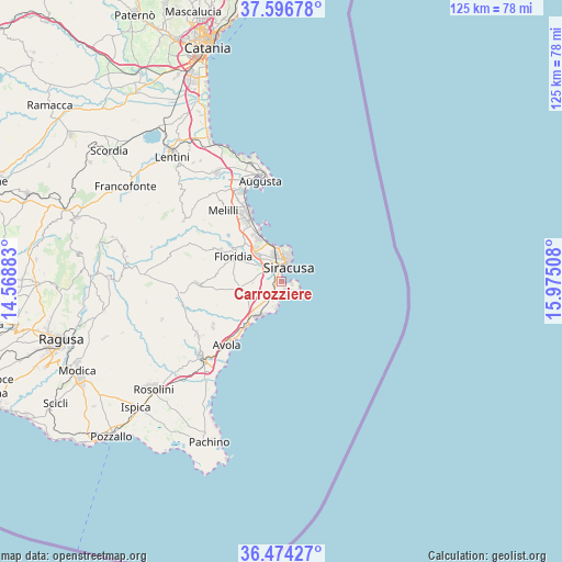
Carrozziere GPS coordinates[2]
37° 2' 15.36" North, 15° 16' 19.02" East
| Map corner | latitude | longitude |
|---|---|---|
| Upper-left | 37.59678°, | 14.56883° |
| Center: | 37.0376°, | 15.27195° |
| Lower-right: | 36.47427°, | 15.97508° |
| Map W x H: | 124.8×124.8 km | = 77.5×77.5mi |
| max Lat: | 47.04031° ⇑99.7% North |
| Carrozziere: | 37.0376° |
| min Lat: | ⇓0.3% South 35.50142° |
| min Long | Carrozziere | max Long |
| 6.69888° | 15.27195° | 18.48682° |
| W 89.4%⇐ | ⇒10.6% E |
Elevation
Elevation of Carrozziere is 12 m = 39 ft, and this is 294.7 m = 967 ft below average elevation for this country.
| Max E: |
2085 m = 6841 ft | 93% |
| Avg. | 306.7 m = 1006 ft | |
| Carrozziere | 12 m = 39 ft | |
Min E: |
-4 m = -13 ft | 7% |
See also: Italy elevation on elevation.city.
Geographical zone
Carrozziere is located in North temperate zone (between Tropic of Cancer and the Arctic Circle). Distance of this Northern Tropic circle is 1512.3 km =939.7 mi to South.| Distance of | km | miles | from Carrozziere |
|---|---|---|---|
| North Pole | 5888.9 | 3659.2 | to North |
| Arctic Circle | 3283 | 2040 | to North |
| Tropic Cancer | 1512.3 | 939.7 | to South |
| Equator | 4118.2 | 2558.9 | to South |


Nearby cities:
15 places around Carrozziere: (largest is in red/bold)
• Arenella
3.9 km =2.4 mi,  193°
193°
• Augusta
23 km =14.3 mi,  348°
348°
• Avola
18.6 km =11.6 mi,  219°
219°
• Belvedere
7.7 km =4.8 mi,  317°
317°
• Canicattini Bagni
18.5 km =11.5 mi,  267°
267°
• Cassibile
9.1 km =5.7 mi, 224°
• Città Giardino
9.2 km =5.7 mi, 324°
• Fanusa
1.8 km =1.1 mi,  156°
156°
• Floridia
11.7 km =7.3 mi,  295°
295°
• Fontane Bianche
9.7 km =6 mi, 215°
• Gallina
14.4 km =8.9 mi, 217°
• Melilli
20.1 km =12.5 mi, 321°
• Priolo Gargallo
15.3 km =9.5 mi,  328°
328°
• Siracusa
4.4 km =2.7 mi,  17°
17°
• Solarino
15.2 km =9.4 mi, 297°
Sources, notices
• [Note1] Compared only with cities in Italy existing in our database
• [Src1] Map data: © OpenStreetMap contributors (CC-BY-SA)
• [Src2] Other city data from geonames.org with taken over terms of usage.
• [Src3] Geographical zone / Annual Mean Temperature by Robert A. Rohde @ Wikipedia
