Augusta geodata
Augusta (Sicily) is a seat of a third-order administrative division; located in Italy in Europe/Rome (GMT+2) time zone. With population of 30,723 people, there are 268 cities with bigger population in this country. Compared to other cities in Italy, 99.4% of cities are located further ↑North; 89% of cities are located further ←West and 93.6% of cities have higher elevation than Augusta. Note1


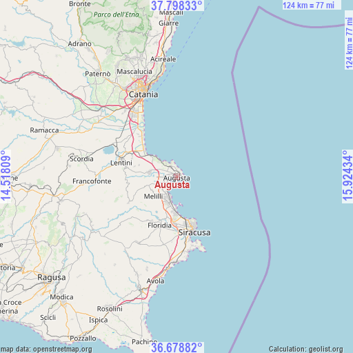
Augusta GPS coordinates[2]
37° 14' 26.34" North, 15° 13' 16.356" East
| Map corner | latitude | longitude |
|---|---|---|
| Upper-left | 37.79833°, | 14.51809° |
| Center: | 37.24065°, | 15.22121° |
| Lower-right: | 36.67882°, | 15.92434° |
| Map W x H: | 124.5×124.5 km | = 77.4×77.4mi |
| max Lat: | 47.04031° ⇑99.4% North |
| Augusta: | 37.24065° |
| min Lat: | ⇓0.6% South 35.50142° |
| min Long | Augusta | max Long |
| 6.69888° | 15.22121° | 18.48682° |
| W 89%⇐ | ⇒11% E |
Elevation
Elevation of Augusta is 11 m = 36 ft, and this is 295.7 m = 970 ft below average elevation for this country.
| Max E: |
2085 m = 6841 ft | 93.6% |
| Avg. | 306.7 m = 1006 ft | |
| Augusta | 11 m = 36 ft | |
Min E: |
-4 m = -13 ft | 6.4% |
See also: Italy elevation on elevation.city.
Geographical zone
Augusta is located in North temperate zone (between Tropic of Cancer and the Arctic Circle). Distance of this Northern Tropic circle is 1534.9 km =953.7 mi to South.| Distance of | km | miles | from Augusta |
|---|---|---|---|
| North Pole | 5866.3 | 3645.1 | to North |
| Arctic Circle | 3260.4 | 2025.9 | to North |
| Tropic Cancer | 1534.9 | 953.7 | to South |
| Equator | 4140.8 | 2573 | to South |


Nearby cities:
15 places around Augusta: (largest is in red/bold)
• Belvedere
16.9 km =10.5 mi,  182°
182°
• Brucoli
5.4 km =3.4 mi,  327°
327°
• Carlentini
19.2 km =11.9 mi,  283°
283°
• Carlentini Nord
19.7 km =12.2 mi,  287°
287°
• Carrozziere
23 km =14.3 mi,  168°
168°
• Città Giardino
15.2 km =9.4 mi, 183°
• Floridia
18.5 km =11.5 mi,  198°
198°
• Lentini
20.4 km =12.7 mi, 284°
• Melilli
10.6 km =6.6 mi,  229°
229°
• Priolo Gargallo
10.1 km =6.3 mi, 199°
• Siracusa
19.3 km =12 mi,  162°
162°
• Solarino
17.9 km =11.1 mi,  210°
210°
• Sortino
19.2 km =11.9 mi,  241°
241°
• Vaccarizzo-Delfino
19.3 km =12 mi,  319°
319°
• Villasmundo
11.6 km =7.2 mi, 275°
Sources, notices
• [Note1] Compared only with cities in Italy existing in our database
• [Src1] Map data: © OpenStreetMap contributors (CC-BY-SA)
• [Src2] Other city data from geonames.org with taken over terms of usage.
• [Src3] Geographical zone / Annual Mean Temperature by Robert A. Rohde @ Wikipedia
