Martelli-Laganosa geodata
Martelli-Laganosa (Calabria) is a populated place; located in Italy in Europe/Rome (GMT+2) time zone. With population of 1,223 people, there are 5889 cities with bigger population in this country. Compared to other cities in Italy, 93.5% of cities are located further ↑North; 96.7% of cities are located further ←West and 87% of cities have higher elevation than Martelli-Laganosa. Note1


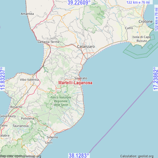
Martelli-Laganosa GPS coordinates[2]
38° 40' 45.48" North, 16° 32' 7.764" East
| Map corner | latitude | longitude |
|---|---|---|
| Upper-left | 39.22609°, | 15.83237° |
| Center: | 38.6793°, | 16.53549° |
| Lower-right: | 38.1283°, | 17.23862° |
| Map W x H: | 122.1×122.1 km | = 75.9×75.9mi |
| max Lat: | 47.04031° ⇑93.5% North |
| Martelli-Laganosa: | 38.6793° |
| min Lat: | ⇓6.5% South 35.50142° |
| min Long | Martelli-Lagano | max Long |
| 6.69888° | 16.53549° | 18.48682° |
| W 96.7%⇐ | ⇒3.3% E |
Elevation
Elevation of Martelli-Laganosa is 25 m = 82 ft, and this is 281.7 m = 924 ft below average elevation for this country.
| Max E: |
2085 m = 6841 ft | 87% |
| Avg. | 306.7 m = 1006 ft | |
| Martelli-Laganosa | 25 m = 82 ft | |
Min E: |
-4 m = -13 ft | 13% |
See also: Italy elevation on elevation.city.
Geographical zone
Martelli-Laganosa is located in North temperate zone (between Tropic of Cancer and the Arctic Circle). Distance of this Northern Tropic circle is 1694.8 km =1053.1 mi to South.| Distance of | km | miles | from Martelli-Laganosa |
|---|---|---|---|
| North Pole | 5706.3 | 3545.7 | to North |
| Arctic Circle | 3100.4 | 1926.5 | to North |
| Tropic Cancer | 1694.8 | 1053.1 | to South |
| Equator | 4300.7 | 2672.3 | to South |


Nearby cities:
15 places around Martelli-Laganosa: (largest is in red/bold)
• Calalunga-Pietragrande
6.7 km =4.2 mi,  10°
10°
• Davoli
5.3 km =3.3 mi,  230°
230°
• Gagliato
6.5 km =4 mi,  266°
266°
• Gasperina
7.2 km =4.5 mi,  339°
339°
• Marina di Davoli
2.1 km =1.3 mi,  147°
147°
• Montepaone
5.8 km =3.6 mi,  325°
325°
• Montepaone Lido
5.6 km =3.5 mi, 6°
• Petrizzi
6.1 km =3.8 mi,  294°
294°
• San Sostene
6.3 km =3.9 mi,  221°
221°
• San Sostene Marina
3.6 km =2.2 mi,  155°
155°
• Sant'Andrea Apostolo dello Ionio
6.4 km =4 mi,  183°
183°
• Sant'Andrea Ionio Marina
6.7 km =4.2 mi,  169°
169°
• Satriano
5.1 km =3.2 mi,  253°
253°
• Soverato Marina
1.4 km =0.9 mi,  63°
63°
• Soverato Superiore
1.2 km =0.7 mi,  353°
353°
Sources, notices
• [Note1] Compared only with cities in Italy existing in our database
• [Src1] Map data: © OpenStreetMap contributors (CC-BY-SA)
• [Src2] Other city data from geonames.org with taken over terms of usage.
• [Src3] Geographical zone / Annual Mean Temperature by Robert A. Rohde @ Wikipedia
