Arlesega geodata
Arlesega (Veneto) is a populated place; located in Italy in Europe/Rome (GMT+2) time zone. With population of 1,013 people, there are 6616 cities with bigger population in this country. Compared to other cities in Italy, 72.3% of cities are located further ↓South; 52.1% of cities are located further ←West and 89% of cities have higher elevation than Arlesega. Note1


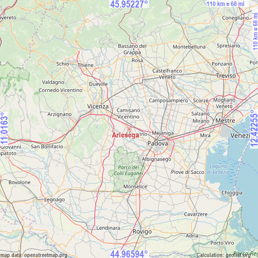
Arlesega GPS coordinates[2]
45° 27' 40.536" North, 11° 43' 9.912" East
| Map corner | latitude | longitude |
|---|---|---|
| Upper-left | 45.95227°, | 11.0163° |
| Center: | 45.46126°, | 11.71942° |
| Lower-right: | 44.96594°, | 12.42255° |
| Map W x H: | 109.7×109.7 km | = 68.2×68.2mi |
| max Lat: | 47.04031° ⇑27.7% North |
| Arlesega: | 45.46126° |
| min Lat: | ⇓72.3% South 35.50142° |
| min Long | Arlesega | max Long |
| 6.69888° | 11.71942° | 18.48682° |
| W 52.1%⇐ | ⇒47.9% E |
Elevation
Elevation of Arlesega is 20 m = 66 ft, and this is 286.7 m = 941 ft below average elevation for this country.
| Max E: |
2085 m = 6841 ft | 89% |
| Avg. | 306.7 m = 1006 ft | |
| Arlesega | 20 m = 66 ft | |
Min E: |
-4 m = -13 ft | 11% |
See also: Italy elevation on elevation.city.
Geographical zone
Arlesega is located in North temperate zone (between Tropic of Cancer and the Arctic Circle). Distance of this North polar circle is 2346.4 km =1458 mi to North.| Distance of | km | miles | from Arlesega |
|---|---|---|---|
| North Pole | 4952.2 | 3077.2 | to North |
| Arctic Circle | 2346.4 | 1458 | to North |
| Tropic Cancer | 2448.9 | 1521.7 | to South |
| Equator | 5054.8 | 3140.9 | to South |


Nearby cities:
15 places around Arlesega: (largest is in red/bold)
• Bevadoro
5.8 km =3.6 mi,  14°
14°
• Bosco
6.2 km =3.9 mi,  108°
108°
• Campodoro
4.1 km =2.5 mi,  39°
39°
• Canton Madonna
5.6 km =3.5 mi,  139°
139°
• Cervarese Santa Croce
4.8 km =3 mi,  210°
210°
• Grisignano di Zocco
3 km =1.9 mi,  342°
342°
• Lissaro
2 km =1.2 mi,  91°
91°
• Mestrino
3.8 km =2.4 mi,  125°
125°
• Montegalda
3.9 km =2.4 mi,  244°
244°
• Montegaldella
4.7 km =2.9 mi, 235°
• Poiana di Granfion
2.9 km =1.8 mi,  16°
16°
• Ronchi di Campanile
4.3 km =2.7 mi, 94°
• San Marco
5.5 km =3.4 mi,  177°
177°
• Sarmego
5.6 km =3.5 mi,  320°
320°
• Veggiano
1.6 km =1 mi,  198°
198°
Sources, notices
• [Note1] Compared only with cities in Italy existing in our database
• [Src1] Map data: © OpenStreetMap contributors (CC-BY-SA)
• [Src2] Other city data from geonames.org with taken over terms of usage.
• [Src3] Geographical zone / Annual Mean Temperature by Robert A. Rohde @ Wikipedia
