Mestrino geodata
Mestrino (Veneto) is a seat of a third-order administrative division; located in Italy in Europe/Rome (GMT+2) time zone. With population of 7,593 people, there are 1285 cities with bigger population in this country. Compared to other cities in Italy, 71.6% of cities are located further ↓South; 52.6% of cities are located further ←West and 89.6% of cities have higher elevation than Mestrino. Note1


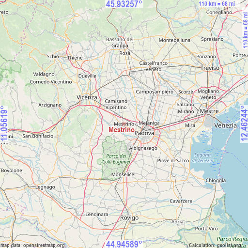
Mestrino GPS coordinates[2]
45° 26' 29.004" North, 11° 45' 33.516" East
| Map corner | latitude | longitude |
|---|---|---|
| Upper-left | 45.93257°, | 11.05619° |
| Center: | 45.44139°, | 11.75931° |
| Lower-right: | 44.94589°, | 12.46244° |
| Map W x H: | 109.7×109.7 km | = 68.2×68.2mi |
| max Lat: | 47.04031° ⇑28.4% North |
| Mestrino: | 45.44139° |
| min Lat: | ⇓71.6% South 35.50142° |
| min Long | Mestrino | max Long |
| 6.69888° | 11.75931° | 18.48682° |
| W 52.6%⇐ | ⇒47.4% E |
Elevation
Elevation of Mestrino is 19 m = 62 ft, and this is 287.7 m = 944 ft below average elevation for this country.
| Max E: |
2085 m = 6841 ft | 89.6% |
| Avg. | 306.7 m = 1006 ft | |
| Mestrino | 19 m = 62 ft | |
Min E: |
-4 m = -13 ft | 10.4% |
See also: Italy elevation on elevation.city.
Geographical zone
Mestrino is located in North temperate zone (between Tropic of Cancer and the Arctic Circle). Distance of this North polar circle is 2348.6 km =1459.4 mi to North.| Distance of | km | miles | from Mestrino |
|---|---|---|---|
| North Pole | 4954.5 | 3078.6 | to North |
| Arctic Circle | 2348.6 | 1459.4 | to North |
| Tropic Cancer | 2446.7 | 1520.3 | to South |
| Equator | 5052.6 | 3139.5 | to South |


Nearby cities:
15 places around Mestrino: (largest is in red/bold)
• Arlesega
3.8 km =2.4 mi,  305°
305°
• Bosco
2.8 km =1.7 mi,  85°
85°
• Campodoro
5.4 km =3.4 mi,  354°
354°
• Canton Madonna
2.1 km =1.3 mi,  165°
165°
• Lissaro
2.4 km =1.5 mi,  333°
333°
• Poiana di Granfion
5.5 km =3.4 mi,  335°
335°
• Ponterotto-Giustizia
5.5 km =3.4 mi,  76°
76°
• Ronchi di Campanile
2.2 km =1.4 mi,  33°
33°
• Rubano
3.1 km =1.9 mi,  125°
125°
• Saccolongo
4.5 km =2.8 mi,  190°
190°
• San Marco
4.3 km =2.7 mi,  220°
220°
• Sarmeola
4.9 km =3 mi,  113°
113°
• Taggì
5.1 km =3.2 mi,  65°
65°
• Veggiano
3.7 km =2.3 mi,  280°
280°
• Villaguattera
4.6 km =2.9 mi, 86°
Sources, notices
• [Note1] Compared only with cities in Italy existing in our database
• [Src1] Map data: © OpenStreetMap contributors (CC-BY-SA)
• [Src2] Other city data from geonames.org with taken over terms of usage.
• [Src3] Geographical zone / Annual Mean Temperature by Robert A. Rohde @ Wikipedia
