Casalbellotto geodata
Casalbellotto (Lombardy) is a populated place; located in Italy in Europe/Rome (GMT+2) time zone. With population of 896 people, there are 7175 cities with bigger population in this country. Compared to other cities in Italy, 59.2% of cities are located further ↓South; 63.1% of cities are located further →East and 87.4% of cities have higher elevation than Casalbellotto. Note1


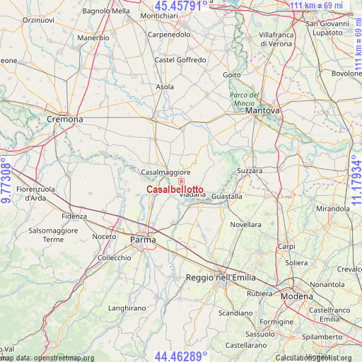
Casalbellotto GPS coordinates[2]
44° 57' 45.216" North, 10° 28' 34.356" East
| Map corner | latitude | longitude |
|---|---|---|
| Upper-left | 45.45791°, | 9.77308° |
| Center: | 44.96256°, | 10.47621° |
| Lower-right: | 44.46289°, | 11.17934° |
| Map W x H: | 110.6×110.6 km | = 68.7×68.7mi |
| max Lat: | 47.04031° ⇑40.8% North |
| Casalbellotto: | 44.96256° |
| min Lat: | ⇓59.2% South 35.50142° |
| min Long | Casalbellotto | max Long |
| 6.69888° | 10.47621° | 18.48682° |
| W 36.9%⇐ | ⇒63.1% E |
Elevation
Elevation of Casalbellotto is 24 m = 79 ft, and this is 282.7 m = 927 ft below average elevation for this country.
| Max E: |
2085 m = 6841 ft | 87.4% |
| Avg. | 306.7 m = 1006 ft | |
| Casalbellotto | 24 m = 79 ft | |
Min E: |
-4 m = -13 ft | 12.6% |
See also: Italy elevation on elevation.city.
Geographical zone
Casalbellotto is located in North temperate zone (between Tropic of Cancer and the Arctic Circle). Distance of this Northern Tropic circle is 2393.4 km =1487.2 mi to South.| Distance of | km | miles | from Casalbellotto |
|---|---|---|---|
| North Pole | 5007.7 | 3111.6 | to North |
| Arctic Circle | 2401.8 | 1492.4 | to North |
| Tropic Cancer | 2393.4 | 1487.2 | to South |
| Equator | 4999.4 | 3106.5 | to South |


Nearby cities:
15 places around Casalbellotto: (largest is in red/bold)
• Boretto
9 km =5.6 mi,  138°
138°
• Breda Cisoni
6.7 km =4.2 mi,  38°
38°
• Brescello
8 km =5 mi,  158°
158°
• Casale
6.2 km =3.9 mi,  214°
214°
• Casale di Mezzani
6.4 km =4 mi, 214°
• Casalmaggiore
5.3 km =3.3 mi,  304°
304°
• Mezzano Inferiore
5.7 km =3.5 mi,  194°
194°
• Mezzano Superiore
5.3 km =3.3 mi,  230°
230°
• Ponteterra
3.7 km =2.3 mi,  345°
345°
• Rivarolo del Re
7.6 km =4.7 mi,  357°
357°
• Roncadello
1.7 km =1.1 mi, 190°
• Sabbioneta
4 km =2.5 mi,  13°
13°
• Viadana
4.5 km =2.8 mi,  131°
131°
• Vicomoscano
2.4 km =1.5 mi, 303°
• Villa Pasquali
5.1 km =3.2 mi, 37°
Sources, notices
• [Note1] Compared only with cities in Italy existing in our database
• [Src1] Map data: © OpenStreetMap contributors (CC-BY-SA)
• [Src2] Other city data from geonames.org with taken over terms of usage.
• [Src3] Geographical zone / Annual Mean Temperature by Robert A. Rohde @ Wikipedia
