Roncadello geodata
Roncadello (Lombardy) is a populated place; located in Italy in Europe/Rome (GMT+1) time zone. With population of 606 people, there are 8947 cities with bigger population in this country. Compared to other cities in Italy, 58.8% of cities are located further ↓South; 63.2% of cities are located further →East and 87.8% of cities have higher elevation than Roncadello. Note1


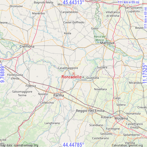
Roncadello GPS coordinates[2]
44° 56' 51.54" North, 10° 28' 19.632" East
| Map corner | latitude | longitude |
|---|---|---|
| Upper-left | 45.44313°, | 9.76899° |
| Center: | 44.94765°, | 10.47212° |
| Lower-right: | 44.44785°, | 11.17525° |
| Map W x H: | 110.7×110.7 km | = 68.8×68.8mi |
| max Lat: | 47.04031° ⇑41.2% North |
| Roncadello: | 44.94765° |
| min Lat: | ⇓58.8% South 35.50142° |
| min Long | Roncadello | max Long |
| 6.69888° | 10.47212° | 18.48682° |
| W 36.8%⇐ | ⇒63.2% E |
Elevation
Elevation of Roncadello is 23 m = 75 ft, and this is 283.7 m = 931 ft below average elevation for this country.
| Max E: |
2085 m = 6841 ft | 87.8% |
| Avg. | 306.7 m = 1006 ft | |
| Roncadello | 23 m = 75 ft | |
Min E: |
-4 m = -13 ft | 12.2% |
See also: Italy elevation on elevation.city.
Geographical zone
Roncadello is located in North temperate zone (between Tropic of Cancer and the Arctic Circle). Distance of this Northern Tropic circle is 2391.8 km =1486.2 mi to South.| Distance of | km | miles | from Roncadello |
|---|---|---|---|
| North Pole | 5009.4 | 3112.7 | to North |
| Arctic Circle | 2403.5 | 1493.5 | to North |
| Tropic Cancer | 2391.8 | 1486.2 | to South |
| Equator | 4997.7 | 3105.4 | to South |


Nearby cities:
15 places around Roncadello: (largest is in red/bold)
• Boretto
8.1 km =5 mi,  129°
129°
• Breda Cisoni
8.2 km =5.1 mi,  33°
33°
• Brescello
6.6 km =4.1 mi,  151°
151°
• Casalbellotto
1.7 km =1.1 mi,  10°
10°
• Casale
4.7 km =2.9 mi,  222°
222°
• Casale di Mezzani
4.9 km =3 mi, 222°
• Casalmaggiore
6.2 km =3.9 mi,  319°
319°
• Colorno
8.1 km =5 mi,  252°
252°
• Mezzano Inferiore
4 km =2.5 mi,  195°
195°
• Mezzano Superiore
4.1 km =2.5 mi, 245°
• Ponteterra
5.3 km =3.3 mi,  353°
353°
• Sabbioneta
5.7 km =3.5 mi, 12°
• Viadana
3.9 km =2.4 mi,  110°
110°
• Vicomoscano
3.5 km =2.2 mi,  330°
330°
• Villa Pasquali
6.7 km =4.2 mi, 30°
Sources, notices
• [Note1] Compared only with cities in Italy existing in our database
• [Src1] Map data: © OpenStreetMap contributors (CC-BY-SA)
• [Src2] Other city data from geonames.org with taken over terms of usage.
• [Src3] Geographical zone / Annual Mean Temperature by Robert A. Rohde @ Wikipedia
