Falda geodata
Falda (Emilia-Romagna) is a populated place; located in Italy in Europe/Rome (GMT+2) time zone. With population of 717 people, there are 8174 cities with bigger population in this country. Compared to other cities in Italy, 55.7% of cities are located further ↑North; 64.2% of cities are located further ←West and 64.9% of cities have higher elevation than Falda. Note1
Administrative division(s):
- Level 1: Emilia-Romagna
- Level 2: Provincia di Rimini
- Level 3: Montefiore Conca


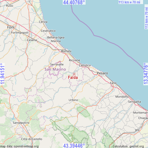
Falda GPS coordinates[2]
43° 54' 11.628" North, 12° 38' 40.668" East
| Map corner | latitude | longitude |
|---|---|---|
| Upper-left | 44.40768°, | 11.94151° |
| Center: | 43.90323°, | 12.64463° |
| Lower-right: | 43.39446°, | 13.34776° |
| Map W x H: | 112.7×112.7 km | = 70×70mi |
| max Lat: | 47.04031° ⇑55.7% North |
| Falda: | 43.90323° |
| min Lat: | ⇓44.3% South 35.50142° |
| min Long | Falda | max Long |
| 6.69888° | 12.64463° | 18.48682° |
| W 64.2%⇐ | ⇒35.8% E |
Elevation
Elevation of Falda is 128 m = 420 ft, and this is 178.7 m = 586 ft below average elevation for this country.
| Max E: |
2085 m = 6841 ft | 64.9% |
| Avg. | 306.7 m = 1006 ft | |
| Falda | 128 m = 420 ft | |
Min E: |
-4 m = -13 ft | 35.1% |
See also: Italy elevation on elevation.city.
Geographical zone
Falda is located in North temperate zone (between Tropic of Cancer and the Arctic Circle). Distance of this Northern Tropic circle is 2275.7 km =1414.1 mi to South.| Distance of | km | miles | from Falda |
|---|---|---|---|
| North Pole | 5125.5 | 3184.8 | to North |
| Arctic Circle | 2519.6 | 1565.6 | to North |
| Tropic Cancer | 2275.7 | 1414.1 | to South |
| Equator | 4881.6 | 3033.3 | to South |


Nearby cities:
15 places around Falda: (largest is in red/bold)
• Croce
5 km =3.1 mi,  297°
297°
• Gemmano
5.1 km =3.2 mi,  270°
270°
• Misano Monte
6.5 km =4 mi,  6°
6°
• Mondaino
5.4 km =3.4 mi,  159°
159°
• Montefiore Conca
3.1 km =1.9 mi,  239°
239°
• Montegridolfo
6.2 km =3.9 mi,  144°
144°
• Morciano di Romagna
1.3 km =0.8 mi,  22°
22°
• Saludecio
3.4 km =2.1 mi, 156°
• San Clemente
3.6 km =2.2 mi,  336°
336°
• San Giovanni in Marignano
6.7 km =4.2 mi,  52°
52°
• San Savino
5.5 km =3.4 mi,  315°
315°
• Sant'Andrea in Casale
3.4 km =2.1 mi, 7°
• Sant'Ansovino
2.3 km =1.4 mi, 162°
• Santa Maria del Monte
3 km =1.9 mi,  113°
113°
• Santa Maria in Pietrafitta
6.7 km =4.2 mi,  66°
66°
Sources, notices
• [Note1] Compared only with cities in Italy existing in our database
• [Src1] Map data: © OpenStreetMap contributors (CC-BY-SA)
• [Src2] Other city data from geonames.org with taken over terms of usage.
• [Src3] Geographical zone / Annual Mean Temperature by Robert A. Rohde @ Wikipedia
