Gemmano geodata
Gemmano (Emilia-Romagna) is a seat of a third-order administrative division; located in Italy in Europe/Rome (GMT+2) time zone. With population of 360 people, there are 10439 cities with bigger population in this country. Compared to other cities in Italy, 55.7% of cities are located further ↑North; 63.3% of cities are located further ←West and 68.6% of cities have lower elevation than Gemmano. Note1


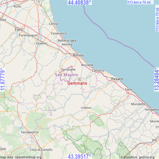
Gemmano GPS coordinates[2]
43° 54' 14.148" North, 12° 34' 51.276" East
| Map corner | latitude | longitude |
|---|---|---|
| Upper-left | 44.40838°, | 11.87779° |
| Center: | 43.90393°, | 12.58091° |
| Lower-right: | 43.39517°, | 13.28404° |
| Map W x H: | 112.7×112.7 km | = 70×70mi |
| max Lat: | 47.04031° ⇑55.7% North |
| Gemmano: | 43.90393° |
| min Lat: | ⇓44.3% South 35.50142° |
| min Long | Gemmano | max Long |
| 6.69888° | 12.58091° | 18.48682° |
| W 63.3%⇐ | ⇒36.7% E |
Elevation
Elevation of Gemmano is 380 m = 1247 ft, and this is 73.3 m = 240 ft above average elevation for this country.
| Max E: |
2085 m = 6841 ft | 31.4% |
| Gemmano | 380 m 1247 ft | |
| Avg. | 306.7 m = 1006 ft | |
Min E: |
-4 m = -13 ft | 68.6% |
See also: Italy elevation on elevation.city.
Geographical zone
Gemmano is located in North temperate zone (between Tropic of Cancer and the Arctic Circle). Distance of this Northern Tropic circle is 2275.7 km =1414.1 mi to South.| Distance of | km | miles | from Gemmano |
|---|---|---|---|
| North Pole | 5125.4 | 3184.8 | to North |
| Arctic Circle | 2519.5 | 1565.5 | to North |
| Tropic Cancer | 2275.7 | 1414.1 | to South |
| Equator | 4881.7 | 3033.3 | to South |


Nearby cities:
15 places around Gemmano: (largest is in red/bold)
• Croce
2.3 km =1.4 mi,  17°
17°
• Falda
5.1 km =3.2 mi,  90°
90°
• Fratte
4.3 km =2.7 mi,  252°
252°
• Monte Colombo
2.9 km =1.8 mi,  308°
308°
• Montefiore Conca
2.9 km =1.8 mi,  123°
123°
• Montescudo
3.5 km =2.2 mi,  295°
295°
• Morciano di Romagna
5.7 km =3.5 mi,  78°
78°
• San Clemente
4.9 km =3 mi,  49°
49°
• San Savino
4.1 km =2.5 mi, 17°
• Sant'Andrea in Casale
6.4 km =4 mi,  59°
59°
• Sant'Ansovino
6.2 km =3.9 mi,  111°
111°
• Sassofeltrio
5.9 km =3.7 mi,  257°
257°
• Taverna
2.1 km =1.3 mi, 296°
• Tavoleto
6.7 km =4.2 mi,  170°
170°
• Trarivi
4.7 km =2.9 mi,  320°
320°
Sources, notices
• [Note1] Compared only with cities in Italy existing in our database
• [Src1] Map data: © OpenStreetMap contributors (CC-BY-SA)
• [Src2] Other city data from geonames.org with taken over terms of usage.
• [Src3] Geographical zone / Annual Mean Temperature by Robert A. Rohde @ Wikipedia
