Borgonuovo geodata
Borgonuovo (Lombardy) is a populated place; located in Italy in Europe/Rome (GMT+2) time zone. With population of 672 people, there are 8471 cities with bigger population in this country. Compared to other cities in Italy, 97.1% of cities are located further ↓South; 74% of cities are located further →East and 72.9% of cities have lower elevation than Borgonuovo. Note1


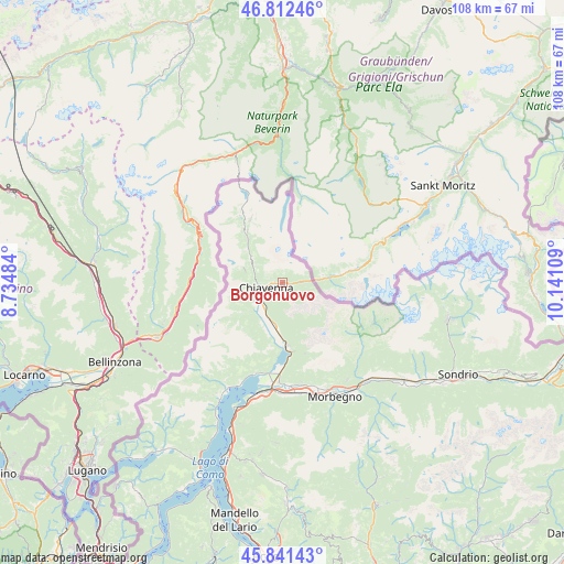
Borgonuovo GPS coordinates[2]
46° 19' 44.76" North, 9° 26' 16.656" East
| Map corner | latitude | longitude |
|---|---|---|
| Upper-left | 46.81246°, | 8.73484° |
| Center: | 46.3291°, | 9.43796° |
| Lower-right: | 45.84143°, | 10.14109° |
| Map W x H: | 108×108 km | = 67.1×67.1mi |
| max Lat: | 47.04031° ⇑2.9% North |
| Borgonuovo: | 46.3291° |
| min Lat: | ⇓97.1% South 35.50142° |
| min Long | Borgonuovo | max Long |
| 6.69888° | 9.43796° | 18.48682° |
| W 26%⇐ | ⇒74% E |
Elevation
Elevation of Borgonuovo is 424 m = 1391 ft, and this is 117.3 m = 385 ft above average elevation for this country.
| Max E: |
2085 m = 6841 ft | 27.1% |
| Borgonuovo | 424 m 1391 ft | |
| Avg. | 306.7 m = 1006 ft | |
Min E: |
-4 m = -13 ft | 72.9% |
See also: Italy elevation on elevation.city.
Geographical zone
Borgonuovo is located in North temperate zone (between Tropic of Cancer and the Arctic Circle). Distance of this North polar circle is 2249.9 km =1398 mi to North.| Distance of | km | miles | from Borgonuovo |
|---|---|---|---|
| North Pole | 4855.7 | 3017.2 | to North |
| Arctic Circle | 2249.9 | 1398 | to North |
| Tropic Cancer | 2545.4 | 1581.6 | to South |
| Equator | 5151.3 | 3200.9 | to South |


Nearby cities:
15 places around Borgonuovo: (largest is in red/bold)
• Chiavenna
3.2 km =2 mi,  252°
252°
• Gordona
6.9 km =4.3 mi,  232°
232°
• Menarola
6.8 km =4.2 mi,  240°
240°
• Mese
5.4 km =3.4 mi, 238°
• Piuro
1.3 km =0.8 mi,  273°
273°
• Prata Camportaccio
4.1 km =2.5 mi, 233°
• Prata Centro
3.9 km =2.4 mi, 234°
• Prosto
1.3 km =0.8 mi, 271°
• San Cassiano
6.6 km =4.1 mi,  208°
208°
• San Giacomo Filippo
5.2 km =3.2 mi,  280°
280°
• San Pietro
8.9 km =5.5 mi, 207°
• San Vittore
4.8 km =3 mi, 240°
• Somaggia
8.5 km =5.3 mi,  188°
188°
• Villa
3.6 km =2.2 mi,  87°
87°
• Villa di Chiavenna
3.3 km =2.1 mi, 86°
Sources, notices
• [Note1] Compared only with cities in Italy existing in our database
• [Src1] Map data: © OpenStreetMap contributors (CC-BY-SA)
• [Src2] Other city data from geonames.org with taken over terms of usage.
• [Src3] Geographical zone / Annual Mean Temperature by Robert A. Rohde @ Wikipedia
