Caredia-Lacco geodata
Caredia-Lacco (Calabria) is a populated place; located in Italy in Europe/Rome (GMT+2) time zone. With population of 669 people, there are 8494 cities with bigger population in this country. Compared to other cities in Italy, 97% of cities are located further ↑North; 91.7% of cities are located further ←West and 65.8% of cities have higher elevation than Caredia-Lacco. Note1
Administrative division(s):
- Level 1: Calabria
- Level 2: Provincia di Reggio Calabria
- Level 3: Melito di Porto Salvo


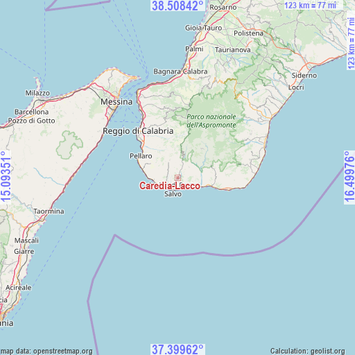
Caredia-Lacco GPS coordinates[2]
37° 57' 21.996" North, 15° 47' 47.868" East
| Map corner | latitude | longitude |
|---|---|---|
| Upper-left | 38.50842°, | 15.09351° |
| Center: | 37.95611°, | 15.79663° |
| Lower-right: | 37.39962°, | 16.49976° |
| Map W x H: | 123.3×123.3 km | = 76.6×76.6mi |
| max Lat: | 47.04031° ⇑97% North |
| Caredia-Lacco: | 37.95611° |
| min Lat: | ⇓3% South 35.50142° |
| min Long | Caredia-Lacco | max Long |
| 6.69888° | 15.79663° | 18.48682° |
| W 91.7%⇐ | ⇒8.3% E |
Elevation
Elevation of Caredia-Lacco is 123 m = 404 ft, and this is 183.7 m = 603 ft below average elevation for this country.
| Max E: |
2085 m = 6841 ft | 65.8% |
| Avg. | 306.7 m = 1006 ft | |
| Caredia-Lacco | 123 m = 404 ft | |
Min E: |
-4 m = -13 ft | 34.2% |
See also: Italy elevation on elevation.city.
Geographical zone
Caredia-Lacco is located in North temperate zone (between Tropic of Cancer and the Arctic Circle). Distance of this Northern Tropic circle is 1614.4 km =1003.1 mi to South.| Distance of | km | miles | from Caredia-Lacco |
|---|---|---|---|
| North Pole | 5786.7 | 3595.7 | to North |
| Arctic Circle | 3180.9 | 1976.5 | to North |
| Tropic Cancer | 1614.4 | 1003.1 | to South |
| Equator | 4220.3 | 2622.4 | to South |


Nearby cities:
15 places around Caredia-Lacco: (largest is in red/bold)
• Bagaladi
8 km =5 mi,  15°
15°
• Chorio
3.6 km =2.2 mi, 22°
• Condofuri
7.6 km =4.7 mi,  44°
44°
• Fossato Ionico-Fossatello-San Luca Marcelluzzo
6.7 km =4.2 mi,  334°
334°
• Marina di San Lorenzo
5 km =3.1 mi,  141°
141°
• Masella
3.9 km =2.4 mi,  286°
286°
• Melito di Porto Salvo
5.3 km =3.3 mi,  231°
231°
• Montebello Jonico
4.5 km =2.8 mi,  311°
311°
• Motta San Giovanni
9.5 km =5.9 mi, 309°
• Prunella
1.7 km =1.1 mi,  183°
183°
• Roghudi
4.4 km =2.7 mi,  218°
218°
• Saline Ioniche
7 km =4.3 mi,  254°
254°
• San Carlo-Condofuri Marina
7.1 km =4.4 mi,  111°
111°
• San Lorenzo
6.9 km =4.3 mi,  28°
28°
• San Pantaleone
5.4 km =3.4 mi,  47°
47°
Sources, notices
• [Note1] Compared only with cities in Italy existing in our database
• [Src1] Map data: © OpenStreetMap contributors (CC-BY-SA)
• [Src2] Other city data from geonames.org with taken over terms of usage.
• [Src3] Geographical zone / Annual Mean Temperature by Robert A. Rohde @ Wikipedia
