Cucco-Riviere geodata
Cucco-Riviere (Calabria) is a populated place; located in Italy in Europe/Rome (GMT+2) time zone. With population of 655 people, there are 8600 cities with bigger population in this country. Compared to other cities in Italy, 89.5% of cities are located further ↑North; 91.8% of cities are located further ←West and 85% of cities have higher elevation than Cucco-Riviere. Note1


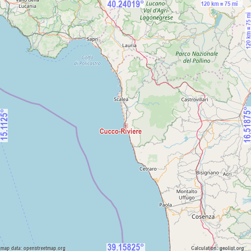
Cucco-Riviere GPS coordinates[2]
39° 42' 4.824" North, 15° 48' 56.232" East
| Map corner | latitude | longitude |
|---|---|---|
| Upper-left | 40.24019°, | 15.1125° |
| Center: | 39.70134°, | 15.81562° |
| Lower-right: | 39.15825°, | 16.51875° |
| Map W x H: | 120.3×120.3 km | = 74.8×74.8mi |
| max Lat: | 47.04031° ⇑89.5% North |
| Cucco-Riviere: | 39.70134° |
| min Lat: | ⇓10.5% South 35.50142° |
| min Long | Cucco-Riviere | max Long |
| 6.69888° | 15.81562° | 18.48682° |
| W 91.8%⇐ | ⇒8.2% E |
Elevation
Elevation of Cucco-Riviere is 31 m = 102 ft, and this is 275.7 m = 905 ft below average elevation for this country.
| Max E: |
2085 m = 6841 ft | 85% |
| Avg. | 306.7 m = 1006 ft | |
| Cucco-Riviere | 31 m = 102 ft | |
Min E: |
-4 m = -13 ft | 15% |
See also: Italy elevation on elevation.city.
Geographical zone
Cucco-Riviere is located in North temperate zone (between Tropic of Cancer and the Arctic Circle). Distance of this Northern Tropic circle is 1808.5 km =1123.7 mi to South.| Distance of | km | miles | from Cucco-Riviere |
|---|---|---|---|
| North Pole | 5592.7 | 3475.1 | to North |
| Arctic Circle | 2986.8 | 1855.9 | to North |
| Tropic Cancer | 1808.5 | 1123.7 | to South |
| Equator | 4414.4 | 2743 | to South |


Nearby cities:
15 places around Cucco-Riviere: (largest is in red/bold)
• Belvedere Marittimo
10 km =6.2 mi,  156°
156°
• Buonvicino
6 km =3.7 mi,  103°
103°
• Cirella
1.5 km =0.9 mi,  342°
342°
• Diamante
2.4 km =1.5 mi,  167°
167°
• Grisolia
4.4 km =2.7 mi,  52°
52°
• Laise
9.3 km =5.8 mi,  149°
149°
• Maierà
3.4 km =2.1 mi,  60°
60°
• Marcellina
7.2 km =4.5 mi,  5°
5°
• Marina di Santa Maria del Cedro
5.9 km =3.7 mi,  353°
353°
• Orsomarso
13.4 km =8.3 mi,  35°
35°
• Sangineto Lido
13.4 km =8.3 mi, 161°
• Santa Domenica Talao
13.5 km =8.4 mi, 14°
• Santa Maria del Cedro
5.3 km =3.3 mi,  19°
19°
• Scalea
11.8 km =7.3 mi, 351°
• Verbicaro
10.3 km =6.4 mi, 49°
Sources, notices
• [Note1] Compared only with cities in Italy existing in our database
• [Src1] Map data: © OpenStreetMap contributors (CC-BY-SA)
• [Src2] Other city data from geonames.org with taken over terms of usage.
• [Src3] Geographical zone / Annual Mean Temperature by Robert A. Rohde @ Wikipedia
