Stazione geodata
Stazione (Piedmont) is a populated place; located in Italy in Europe/Rome (GMT+2) time zone. With population of 624 people, there are 8809 cities with bigger population in this country. Compared to other cities in Italy, 59.1% of cities are located further ↓South; 94.2% of cities are located further →East and 54.1% of cities have lower elevation than Stazione. Note1


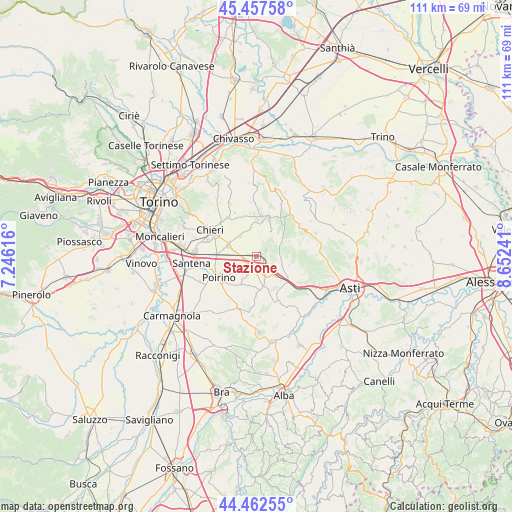
Stazione GPS coordinates[2]
44° 57' 43.992" North, 7° 56' 57.444" East
| Map corner | latitude | longitude |
|---|---|---|
| Upper-left | 45.45758°, | 7.24616° |
| Center: | 44.96222°, | 7.94929° |
| Lower-right: | 44.46255°, | 8.65241° |
| Map W x H: | 110.6×110.6 km | = 68.7×68.7mi |
| max Lat: | 47.04031° ⇑40.9% North |
| Stazione: | 44.96222° |
| min Lat: | ⇓59.1% South 35.50142° |
| min Long | Stazione | max Long |
| 6.69888° | 7.94929° | 18.48682° |
| W 5.8%⇐ | ⇒94.2% E |
Elevation
Elevation of Stazione is 260 m = 853 ft, and this is 46.7 m = 153 ft below average elevation for this country.
| Max E: |
2085 m = 6841 ft | 45.9% |
| Avg. | 306.7 m = 1006 ft | |
| Stazione | 260 m = 853 ft | |
Min E: |
-4 m = -13 ft | 54.1% |
See also: Italy elevation on elevation.city.
Geographical zone
Stazione is located in North temperate zone (between Tropic of Cancer and the Arctic Circle). Distance of this Northern Tropic circle is 2393.4 km =1487.2 mi to South.| Distance of | km | miles | from Stazione |
|---|---|---|---|
| North Pole | 5007.7 | 3111.6 | to North |
| Arctic Circle | 2401.8 | 1492.4 | to North |
| Tropic Cancer | 2393.4 | 1487.2 | to South |
| Equator | 4999.3 | 3106.4 | to South |


Nearby cities:
15 places around Stazione: (largest is in red/bold)
• Buttigliera d'Asti
6.6 km =4.1 mi,  1°
1°
• Capriglio
6.6 km =4.1 mi,  45°
45°
• Cortandone
8.6 km =5.3 mi,  92°
92°
• Dusino
4.4 km =2.7 mi,  156°
156°
• Isolabella
7 km =4.3 mi,  207°
207°
• Maretto
6.9 km =4.3 mi,  106°
106°
• Montafia
6.6 km =4.1 mi,  63°
63°
• Moriondo Torinese
8.5 km =5.3 mi,  355°
355°
• Pessione
8.5 km =5.3 mi,  272°
272°
• Riva Presso Chieri
6.4 km =4 mi,  291°
291°
• Roatto
6.2 km =3.9 mi,  100°
100°
• San Paolo Solbrito
2.1 km =1.3 mi,  127°
127°
• Valfenera
6.8 km =4.2 mi,  170°
170°
• Villafranca d'Asti
8 km =5 mi, 130°
• Villanova d'Asti
2.4 km =1.5 mi,  204°
204°
Sources, notices
• [Note1] Compared only with cities in Italy existing in our database
• [Src1] Map data: © OpenStreetMap contributors (CC-BY-SA)
• [Src2] Other city data from geonames.org with taken over terms of usage.
• [Src3] Geographical zone / Annual Mean Temperature by Robert A. Rohde @ Wikipedia
