Corigliano geodata
Corigliano (Campania) is a populated place; located in Italy in Europe/Rome (GMT+2) time zone. With population of 584 people, there are 9143 cities with bigger population in this country. Compared to other cities in Italy, 79.7% of cities are located further ↑North; 79.4% of cities are located further ←West and 67.8% of cities have higher elevation than Corigliano. Note1


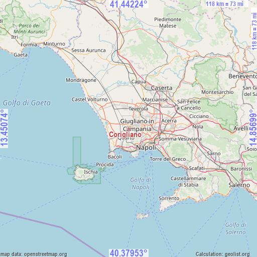
Corigliano GPS coordinates[2]
40° 54' 46.872" North, 14° 9' 13.896" East
| Map corner | latitude | longitude |
|---|---|---|
| Upper-left | 41.44224°, | 13.45074° |
| Center: | 40.91302°, | 14.15386° |
| Lower-right: | 40.37953°, | 14.85699° |
| Map W x H: | 118.2×118.2 km | = 73.4×73.4mi |
| max Lat: | 47.04031° ⇑79.7% North |
| Corigliano: | 40.91302° |
| min Lat: | ⇓20.3% South 35.50142° |
| min Long | Corigliano | max Long |
| 6.69888° | 14.15386° | 18.48682° |
| W 79.4%⇐ | ⇒20.6% E |
Elevation
Elevation of Corigliano is 110 m = 361 ft, and this is 196.7 m = 645 ft below average elevation for this country.
| Max E: |
2085 m = 6841 ft | 67.8% |
| Avg. | 306.7 m = 1006 ft | |
| Corigliano | 110 m = 361 ft | |
Min E: |
-4 m = -13 ft | 32.2% |
See also: Italy elevation on elevation.city.
Geographical zone
Corigliano is located in North temperate zone (between Tropic of Cancer and the Arctic Circle). Distance of this Northern Tropic circle is 1943.2 km =1207.4 mi to South.| Distance of | km | miles | from Corigliano |
|---|---|---|---|
| North Pole | 5458 | 3391.4 | to North |
| Arctic Circle | 2852.1 | 1772.2 | to North |
| Tropic Cancer | 1943.2 | 1207.4 | to South |
| Equator | 4549.1 | 2826.7 | to South |


Nearby cities:
15 places around Corigliano: (largest is in red/bold)
• Amodio-Massariola
5.9 km =3.7 mi,  242°
242°
• Calvizzano
2.7 km =1.7 mi,  102°
102°
• Castello Monteleone
2.9 km =1.8 mi, 242°
• Chiaiano
5.7 km =3.5 mi,  128°
128°
• Giugliano in Campania
4.4 km =2.7 mi,  66°
66°
• Grotta dell'Olmo I
5.6 km =3.5 mi,  247°
247°
• Marano di Napoli
3.4 km =2.1 mi,  121°
121°
• Mugnano di Napoli
4.7 km =2.9 mi,  94°
94°
• Parete
5.1 km =3.2 mi,  7°
7°
• Qualiano
0.7 km =0.4 mi,  357°
357°
• Quarto
4 km =2.5 mi,  192°
192°
• San Pietro
1 km =0.6 mi,  112°
112°
• Torre Caracciolo
4.7 km =2.9 mi,  153°
153°
• Torretta-Scalzapecora
1.7 km =1.1 mi,  258°
258°
• Villaricca
3.4 km =2.1 mi,  76°
76°
Sources, notices
• [Note1] Compared only with cities in Italy existing in our database
• [Src1] Map data: © OpenStreetMap contributors (CC-BY-SA)
• [Src2] Other city data from geonames.org with taken over terms of usage.
• [Src3] Geographical zone / Annual Mean Temperature by Robert A. Rohde @ Wikipedia
