Chimento geodata
Chimento (Calabria) is a populated place; located in Italy in Europe/Rome (GMT+2) time zone. With population of 572 people, there are 9247 cities with bigger population in this country. Compared to other cities in Italy, 90.1% of cities are located further ↑North; 96.2% of cities are located further ←West and 81.3% of cities have lower elevation than Chimento. Note1


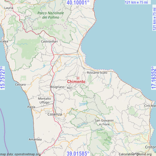
Chimento GPS coordinates[2]
39° 33' 36.18" North, 16° 27' 37.404" East
| Map corner | latitude | longitude |
|---|---|---|
| Upper-left | 40.10001°, | 15.75727° |
| Center: | 39.56005°, | 16.46039° |
| Lower-right: | 39.01585°, | 17.16352° |
| Map W x H: | 120.5×120.5 km | = 74.9×74.9mi |
| max Lat: | 47.04031° ⇑90.1% North |
| Chimento: | 39.56005° |
| min Lat: | ⇓9.9% South 35.50142° |
| min Long | Chimento | max Long |
| 6.69888° | 16.46039° | 18.48682° |
| W 96.2%⇐ | ⇒3.8% E |
Elevation
Elevation of Chimento is 543 m = 1781 ft, and this is 236.3 m = 775 ft above average elevation for this country.
| Max E: |
2085 m = 6841 ft | 18.7% |
| Chimento | 543 m 1781 ft | |
| Avg. | 306.7 m = 1006 ft | |
Min E: |
-4 m = -13 ft | 81.3% |
See also: Italy elevation on elevation.city.
Geographical zone
Chimento is located in North temperate zone (between Tropic of Cancer and the Arctic Circle). Distance of this Northern Tropic circle is 1792.7 km =1113.9 mi to South.| Distance of | km | miles | from Chimento |
|---|---|---|---|
| North Pole | 5608.4 | 3484.9 | to North |
| Arctic Circle | 3002.5 | 1865.7 | to North |
| Tropic Cancer | 1792.7 | 1113.9 | to South |
| Equator | 4398.7 | 2733.2 | to South |


Nearby cities:
15 places around Chimento: (largest is in red/bold)
• Acri
9.5 km =5.9 mi,  221°
221°
• Cantinella
11.7 km =7.3 mi,  355°
355°
• Corigliano Calabro
6.4 km =4 mi,  51°
51°
• Corigliano Scalo
8.7 km =5.4 mi,  31°
31°
• Foresta
3.1 km =1.9 mi,  80°
80°
• Macchia
6.9 km =4.3 mi,  207°
207°
• Marina di Schiavonea
11.8 km =7.3 mi, 31°
• Pertina
5.1 km =3.2 mi,  198°
198°
• Piragineti
11.2 km =7 mi,  60°
60°
• San Cosmo Albanese
4.7 km =2.9 mi,  303°
303°
• San Demetrio Corone
8.5 km =5.3 mi,  277°
277°
• San Giacomo
3.9 km =2.4 mi,  175°
175°
• San Giorgio Albanese
2.5 km =1.6 mi,  346°
346°
• Santa Sofia d'Epiro
11.4 km =7.1 mi,  262°
262°
• Vaccarizzo Albanese
3.7 km =2.3 mi,  320°
320°
Sources, notices
• [Note1] Compared only with cities in Italy existing in our database
• [Src1] Map data: © OpenStreetMap contributors (CC-BY-SA)
• [Src2] Other city data from geonames.org with taken over terms of usage.
• [Src3] Geographical zone / Annual Mean Temperature by Robert A. Rohde @ Wikipedia
