Piragineti geodata
Piragineti (Calabria) is a populated place; located in Italy in Europe/Rome (GMT+2) time zone. With population of 982 people, there are 6735 cities with bigger population in this country. Compared to other cities in Italy, 89.8% of cities are located further ↑North; 96.9% of cities are located further ←West and 74% of cities have higher elevation than Piragineti. Note1
Administrative division(s):
- Level 1: Calabria
- Level 2: Provincia di Cosenza
- Level 3: Corigliano-Rossano


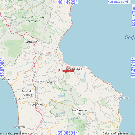
Piragineti GPS coordinates[2]
39° 36' 34.992" North, 16° 34' 26.328" East
| Map corner | latitude | longitude |
|---|---|---|
| Upper-left | 40.14929°, | 15.87086° |
| Center: | 39.60972°, | 16.57398° |
| Lower-right: | 39.06591°, | 17.27711° |
| Map W x H: | 120.5×120.5 km | = 74.9×74.9mi |
| max Lat: | 47.04031° ⇑89.8% North |
| Piragineti: | 39.60972° |
| min Lat: | ⇓10.2% South 35.50142° |
| min Long | Piragineti | max Long |
| 6.69888° | 16.57398° | 18.48682° |
| W 96.9%⇐ | ⇒3.1% E |
Elevation
Elevation of Piragineti is 78 m = 256 ft, and this is 228.7 m = 750 ft below average elevation for this country.
| Max E: |
2085 m = 6841 ft | 74% |
| Avg. | 306.7 m = 1006 ft | |
| Piragineti | 78 m = 256 ft | |
Min E: |
-4 m = -13 ft | 26% |
See also: Italy elevation on elevation.city.
Geographical zone
Piragineti is located in North temperate zone (between Tropic of Cancer and the Arctic Circle). Distance of this Northern Tropic circle is 1798.3 km =1117.4 mi to South.| Distance of | km | miles | from Piragineti |
|---|---|---|---|
| North Pole | 5602.9 | 3481.5 | to North |
| Arctic Circle | 2997 | 1862.2 | to North |
| Tropic Cancer | 1798.3 | 1117.4 | to South |
| Equator | 4404.2 | 2736.6 | to South |


Nearby cities:
15 places around Piragineti: (largest is in red/bold)
• Amica
8 km =5 mi,  97°
97°
• Cantinella
12.3 km =7.6 mi,  299°
299°
• Chimento
11.2 km =7 mi,  240°
240°
• Corigliano Calabro
5 km =3.1 mi,  251°
251°
• Corigliano Scalo
5.5 km =3.4 mi,  290°
290°
• Fabrizio
3.6 km =2.2 mi,  335°
335°
• Foresta
8.3 km =5.2 mi,  232°
232°
• Marina di Schiavonea
5.7 km =3.5 mi,  322°
322°
• Paludi
12.7 km =7.9 mi,  134°
134°
• Rossano
6.4 km =4 mi, 125°
• Rossano Stazione
5.4 km =3.4 mi, 103°
• San Giacomo
13.3 km =8.3 mi, 225°
• San Giorgio Albanese
10.8 km =6.7 mi, 253°
• San Nico
13.8 km =8.6 mi, 298°
• Vaccarizzo Albanese
12.4 km =7.7 mi,  257°
257°
Sources, notices
• [Note1] Compared only with cities in Italy existing in our database
• [Src1] Map data: © OpenStreetMap contributors (CC-BY-SA)
• [Src2] Other city data from geonames.org with taken over terms of usage.
• [Src3] Geographical zone / Annual Mean Temperature by Robert A. Rohde @ Wikipedia
