Scalera geodata
Scalera (Basilicate) is a populated place; located in Italy in Europe/Rome (GMT+2) time zone. With population of 548 people, there are 9471 cities with bigger population in this country. Compared to other cities in Italy, 80.6% of cities are located further ↑North; 91.3% of cities are located further ←West and 87.7% of cities have lower elevation than Scalera. Note1


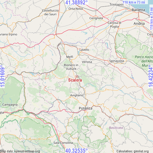
Scalera GPS coordinates[2]
40° 51' 33.372" North, 15° 43' 9.156" East
| Map corner | latitude | longitude |
|---|---|---|
| Upper-left | 41.38892°, | 15.01609° |
| Center: | 40.85927°, | 15.71921° |
| Lower-right: | 40.32535°, | 16.42234° |
| Map W x H: | 118.3×118.3 km | = 73.5×73.5mi |
| max Lat: | 47.04031° ⇑80.6% North |
| Scalera: | 40.85927° |
| min Lat: | ⇓19.4% South 35.50142° |
| min Long | Scalera | max Long |
| 6.69888° | 15.71921° | 18.48682° |
| W 91.3%⇐ | ⇒8.7% E |
Elevation
Elevation of Scalera is 668 m = 2192 ft, and this is 361.3 m = 1185 ft above average elevation for this country.
| Max E: |
2085 m = 6841 ft | 12.3% |
| Scalera | 668 m 2192 ft | |
| Avg. | 306.7 m = 1006 ft | |
Min E: |
-4 m = -13 ft | 87.7% |
See also: Italy elevation on elevation.city.
Geographical zone
Scalera is located in North temperate zone (between Tropic of Cancer and the Arctic Circle). Distance of this Northern Tropic circle is 1937.2 km =1203.7 mi to South.| Distance of | km | miles | from Scalera |
|---|---|---|---|
| North Pole | 5463.9 | 3395.1 | to North |
| Arctic Circle | 2858 | 1775.9 | to North |
| Tropic Cancer | 1937.2 | 1203.7 | to South |
| Equator | 4543.1 | 2823 | to South |


Nearby cities:
15 places around Scalera: (largest is in red/bold)
• Atella
6 km =3.7 mi,  290°
290°
• Barile
10.2 km =6.3 mi,  336°
336°
• Cappelluccia
14 km =8.7 mi,  151°
151°
• Filiano
5.5 km =3.4 mi,  188°
188°
• Forenza
11.4 km =7.1 mi,  89°
89°
• Ginestra
8.1 km =5 mi,  9°
9°
• Lagopesole
6.3 km =3.9 mi,  168°
168°
• Maschito
10.8 km =6.7 mi,  59°
59°
• Possidente
9.8 km =6.1 mi, 151°
• Rapolla
13.5 km =8.4 mi, 342°
• Rionero in Vulture
8.2 km =5.1 mi,  330°
330°
• Ripacandida
6 km =3.7 mi, 5°
• San Cataldo
13.8 km =8.6 mi,  199°
199°
• San Giorgio
11.8 km =7.3 mi, 145°
• Venosa
13.9 km =8.6 mi,  34°
34°
Sources, notices
• [Note1] Compared only with cities in Italy existing in our database
• [Src1] Map data: © OpenStreetMap contributors (CC-BY-SA)
• [Src2] Other city data from geonames.org with taken over terms of usage.
• [Src3] Geographical zone / Annual Mean Temperature by Robert A. Rohde @ Wikipedia
