Ripacandida geodata
Ripacandida (Basilicate) is a seat of a third-order administrative division; located in Italy in Europe/Rome (GMT+2) time zone. With population of 1,508 people, there are 5095 cities with bigger population in this country. Compared to other cities in Italy, 79.8% of cities are located further ↑North; 91.4% of cities are located further ←West and 83% of cities have lower elevation than Ripacandida. Note1


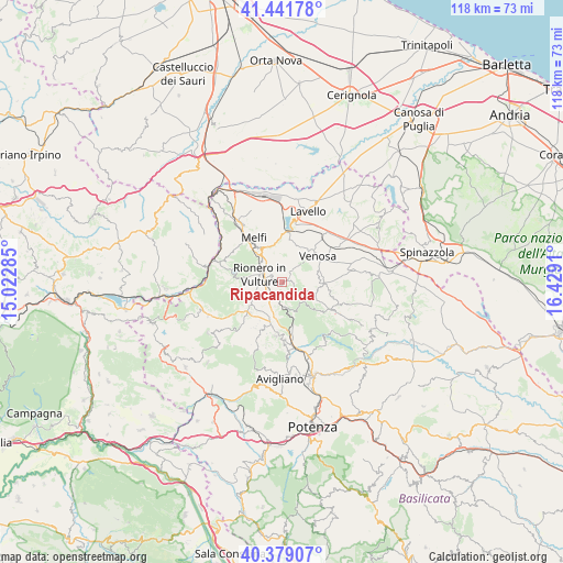
Ripacandida GPS coordinates[2]
40° 54' 45.216" North, 15° 43' 33.492" East
| Map corner | latitude | longitude |
|---|---|---|
| Upper-left | 41.44178°, | 15.02285° |
| Center: | 40.91256°, | 15.72597° |
| Lower-right: | 40.37907°, | 16.4291° |
| Map W x H: | 118.2×118.2 km | = 73.4×73.4mi |
| max Lat: | 47.04031° ⇑79.8% North |
| Ripacandida: | 40.91256° |
| min Lat: | ⇓20.2% South 35.50142° |
| min Long | Ripacandida | max Long |
| 6.69888° | 15.72597° | 18.48682° |
| W 91.4%⇐ | ⇒8.6% E |
Elevation
Elevation of Ripacandida is 572 m = 1877 ft, and this is 265.3 m = 870 ft above average elevation for this country.
| Max E: |
2085 m = 6841 ft | 17% |
| Ripacandida | 572 m 1877 ft | |
| Avg. | 306.7 m = 1006 ft | |
Min E: |
-4 m = -13 ft | 83% |
See also: Italy elevation on elevation.city.
Geographical zone
Ripacandida is located in North temperate zone (between Tropic of Cancer and the Arctic Circle). Distance of this Northern Tropic circle is 1943.1 km =1207.4 mi to South.| Distance of | km | miles | from Ripacandida |
|---|---|---|---|
| North Pole | 5458 | 3391.4 | to North |
| Arctic Circle | 2852.1 | 1772.2 | to North |
| Tropic Cancer | 1943.1 | 1207.4 | to South |
| Equator | 4549.1 | 2826.7 | to South |


Nearby cities:
15 places around Ripacandida: (largest is in red/bold)
• Atella
7.3 km =4.5 mi,  238°
238°
• Barile
5.7 km =3.5 mi,  306°
306°
• Filiano
11.4 km =7.1 mi,  186°
186°
• Forenza
12.3 km =7.6 mi,  118°
118°
• Ginestra
2.2 km =1.4 mi,  20°
20°
• Lagopesole
12.2 km =7.6 mi,  176°
176°
• Lavello
15.9 km =9.9 mi, 19°
• Maschito
8.7 km =5.4 mi,  92°
92°
• Melfi
11 km =6.8 mi,  327°
327°
• Possidente
15.1 km =9.4 mi,  164°
164°
• Rapolla
8.3 km =5.2 mi, 326°
• Rionero in Vulture
4.8 km =3 mi,  284°
284°
• Scalera
6 km =3.7 mi, 185°
• Venosa
9.2 km =5.7 mi,  52°
52°
• Zona 179
13.5 km =8.4 mi,  318°
318°
Sources, notices
• [Note1] Compared only with cities in Italy existing in our database
• [Src1] Map data: © OpenStreetMap contributors (CC-BY-SA)
• [Src2] Other city data from geonames.org with taken over terms of usage.
• [Src3] Geographical zone / Annual Mean Temperature by Robert A. Rohde @ Wikipedia
