Dagnente geodata
Dagnente (Piedmont) is a populated place; located in Italy in Europe/Rome (GMT+2) time zone. With population of 518 people, there are 9748 cities with bigger population in this country. Compared to other cities in Italy, 85% of cities are located further ↓South; 87.6% of cities are located further →East and 68.1% of cities have lower elevation than Dagnente. Note1


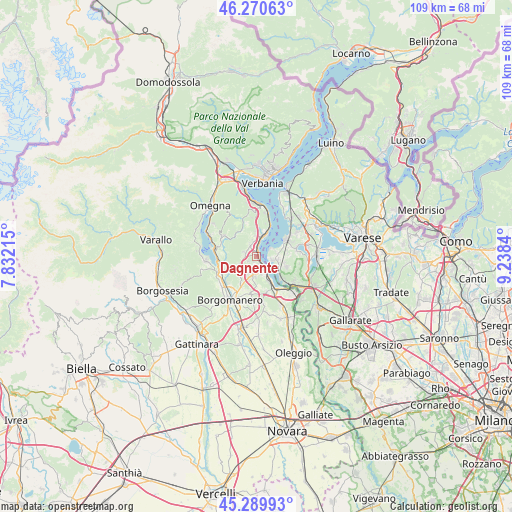
Dagnente GPS coordinates[2]
45° 46' 56.784" North, 8° 32' 7.008" East
| Map corner | latitude | longitude |
|---|---|---|
| Upper-left | 46.27063°, | 7.83215° |
| Center: | 45.78244°, | 8.53528° |
| Lower-right: | 45.28993°, | 9.2384° |
| Map W x H: | 109×109 km | = 67.7×67.7mi |
| max Lat: | 47.04031° ⇑15% North |
| Dagnente: | 45.78244° |
| min Lat: | ⇓85% South 35.50142° |
| min Long | Dagnente | max Long |
| 6.69888° | 8.53528° | 18.48682° |
| W 12.4%⇐ | ⇒87.6% E |
Elevation
Elevation of Dagnente is 374 m = 1227 ft, and this is 67.3 m = 221 ft above average elevation for this country.
| Max E: |
2085 m = 6841 ft | 31.9% |
| Dagnente | 374 m 1227 ft | |
| Avg. | 306.7 m = 1006 ft | |
Min E: |
-4 m = -13 ft | 68.1% |
See also: Italy elevation on elevation.city.
Geographical zone
Dagnente is located in North temperate zone (between Tropic of Cancer and the Arctic Circle). Distance of this North polar circle is 2310.6 km =1435.7 mi to North.| Distance of | km | miles | from Dagnente |
|---|---|---|---|
| North Pole | 4916.5 | 3055 | to North |
| Arctic Circle | 2310.6 | 1435.7 | to North |
| Tropic Cancer | 2484.6 | 1543.9 | to South |
| Equator | 5090.5 | 3163.1 | to South |


Nearby cities:
15 places around Dagnente: (largest is in red/bold)
• Angera
3.4 km =2.1 mi,  102°
102°
• Arona
3.1 km =1.9 mi,  147°
147°
• Barquedo
5.3 km =3.3 mi,  214°
214°
• Colazza
2.9 km =1.8 mi,  292°
292°
• Dormelletto
5.7 km =3.5 mi, 154°
• Ghevio
2.5 km =1.6 mi,  268°
268°
• Invorio
4.7 km =2.9 mi,  232°
232°
• Lesa
4.7 km =2.9 mi,  23°
23°
• Massino Visconti
4.7 km =2.9 mi,  5°
5°
• Meina
1 km =0.6 mi, 10°
• Nebbiuno
2.9 km =1.8 mi,  345°
345°
• Oleggio Castello
3.8 km =2.4 mi,  189°
189°
• Paruzzaro
4.1 km =2.5 mi,  202°
202°
• Pisano
2.2 km =1.4 mi,  312°
312°
• Ranco
3.2 km =2 mi,  59°
59°
Sources, notices
• [Note1] Compared only with cities in Italy existing in our database
• [Src1] Map data: © OpenStreetMap contributors (CC-BY-SA)
• [Src2] Other city data from geonames.org with taken over terms of usage.
• [Src3] Geographical zone / Annual Mean Temperature by Robert A. Rohde @ Wikipedia
