Angera geodata
Angera (Lombardy) is a seat of a third-order administrative division; located in Italy in Europe/Rome (GMT+2) time zone. With population of 4,724 people, there are 2063 cities with bigger population in this country. Compared to other cities in Italy, 84.7% of cities are located further ↓South; 86.9% of cities are located further →East and 52.7% of cities have higher elevation than Angera. Note1


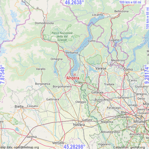
Angera GPS coordinates[2]
45° 46' 31.98" North, 8° 34' 42.996" East
| Map corner | latitude | longitude |
|---|---|---|
| Upper-left | 46.2638°, | 7.87549° |
| Center: | 45.77555°, | 8.57861° |
| Lower-right: | 45.28298°, | 9.28174° |
| Map W x H: | 109.1×109.1 km | = 67.8×67.8mi |
| max Lat: | 47.04031° ⇑15.3% North |
| Angera: | 45.77555° |
| min Lat: | ⇓84.7% South 35.50142° |
| min Long | Angera | max Long |
| 6.69888° | 8.57861° | 18.48682° |
| W 13.1%⇐ | ⇒86.9% E |
Elevation
Elevation of Angera is 218 m = 715 ft, and this is 88.7 m = 291 ft below average elevation for this country.
| Max E: |
2085 m = 6841 ft | 52.7% |
| Avg. | 306.7 m = 1006 ft | |
| Angera | 218 m = 715 ft | |
Min E: |
-4 m = -13 ft | 47.3% |
See also: Italy elevation on elevation.city.
Geographical zone
Angera is located in North temperate zone (between Tropic of Cancer and the Arctic Circle). Distance of this North polar circle is 2311.4 km =1436.2 mi to North.| Distance of | km | miles | from Angera |
|---|---|---|---|
| North Pole | 4917.3 | 3055.5 | to North |
| Arctic Circle | 2311.4 | 1436.2 | to North |
| Tropic Cancer | 2483.8 | 1543.4 | to South |
| Equator | 5089.8 | 3162.7 | to South |


Nearby cities:
15 places around Angera: (largest is in red/bold)
• Arona
2.5 km =1.6 mi,  221°
221°
• Cadrezzate
5.7 km =3.5 mi,  62°
62°
• Dagnente
3.4 km =2.1 mi,  282°
282°
• Dormelletto
4.5 km =2.8 mi,  192°
192°
• Ghevio
5.9 km =3.7 mi, 276°
• Ispra
5.1 km =3.2 mi,  31°
31°
• Lesa
5.2 km =3.2 mi,  343°
343°
• Lisanza
4.3 km =2.7 mi,  159°
159°
• Meina
3.6 km =2.2 mi,  298°
298°
• Nebbiuno
5.4 km =3.4 mi,  311°
311°
• Oleggio Castello
5 km =3.1 mi,  233°
233°
• Paruzzaro
5.8 km =3.6 mi,  238°
238°
• Pisano
5.4 km =3.4 mi,  294°
294°
• Ranco
2.5 km =1.6 mi,  346°
346°
• Taino
3.3 km =2.1 mi,  116°
116°
Sources, notices
• [Note1] Compared only with cities in Italy existing in our database
• [Src1] Map data: © OpenStreetMap contributors (CC-BY-SA)
• [Src2] Other city data from geonames.org with taken over terms of usage.
• [Src3] Geographical zone / Annual Mean Temperature by Robert A. Rohde @ Wikipedia
