Shibata geodata
Shibata (Niigata) is a seat of a second-order administrative division; located in Japan in Asia/Tokyo (GMT+9) time zone. With population of 80,793 people, there are 249 cities with bigger population in this country. Compared to other cities in Japan, 86.8% of cities are located further ↓South; 65% of cities are located further ←West and 73.6% of cities have higher elevation than Shibata. Note1


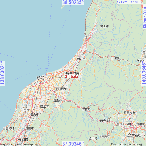
Shibata GPS coordinates[2]
37° 57' 0" North, 139° 19' 59.988" East
| Map corner | latitude | longitude |
|---|---|---|
| Upper-left | 38.50235°, | 138.63021° |
| Center: | 37.95°, | 139.33333° |
| Lower-right: | 37.39346°, | 140.03646° |
| Map W x H: | 123.3×123.3 km | = 76.6×76.6mi |
| max Lat: | 45.40944° ⇑13.2% North |
| Shibata: | 37.95° |
| min Lat: | ⇓86.8% South 24.34478° |
| min Long | Shibata | max Long |
| 123° | 139.33333° | 145.575° |
| W 65%⇐ | ⇒35% E |
Elevation
Elevation of Shibata is 10 m = 33 ft, and this is 74.6 m = 245 ft below average elevation for this country.
| Max E: |
1086 m = 3563 ft | 73.6% |
| Avg. | 84.6 m = 278 ft | |
| Shibata | 10 m = 33 ft | |
Min E: |
-2 m = -7 ft | 26.4% |
See also: Shibata elevation on elevation.city.
Geographical zone
Shibata is located in North temperate zone (between Tropic of Cancer and the Arctic Circle). Distance of this Northern Tropic circle is 1613.7 km =1002.7 mi to South.| Distance of | km | miles | from Shibata |
|---|---|---|---|
| North Pole | 5787.4 | 3596.1 | to North |
| Arctic Circle | 3181.5 | 1976.9 | to North |
| Tropic Cancer | 1613.7 | 1002.7 | to South |
| Equator | 4219.6 | 2621.9 | to South |


Nearby cities:
15 places around Shibata: (largest is in red/bold)
• Agano
21.9 km =13.6 mi,  206°
206°
• Gosen
28.2 km =17.5 mi, 211°
• Kameda-honchō
21.4 km =13.3 mi,  246°
246°
• Kamo
41.2 km =25.6 mi,  219°
219°
• Maki
45.3 km =28.1 mi,  240°
240°
• Murakami
34.1 km =21.2 mi,  22°
22°
• Muramatsu
32 km =19.9 mi, 206°
• Niigata
29.6 km =18.4 mi,  256°
256°
• Niitsu-honchō
24.9 km =15.5 mi,  228°
228°
• Sanjō
50.1 km =31.1 mi, 222°
• Shirone
34.3 km =21.3 mi, 232°
• Suibara
14.7 km =9.1 mi, 218°
• Tainai
13.4 km =8.3 mi, 15°
• Tsubame
47.9 km =29.8 mi, 228°
• Yoshida-kasugachō
49.4 km =30.7 mi, 233°
Sources, notices
• [Note1] Compared only with cities in Japan existing in our database
• [Src1] Map data: © OpenStreetMap contributors (CC-BY-SA)
• [Src2] Other city data from geonames.org with taken over terms of usage.
• [Src3] Geographical zone / Annual Mean Temperature by Robert A. Rohde @ Wikipedia
