Wako geodata
Wako (Saitama) is a seat of a second-order administrative division; located in Japan in Asia/Tokyo (GMT+9) time zone. With population of 77,435 people, there are 259 cities with bigger population in this country. Compared to other cities in Japan, 61.7% of cities are located further ↓South; 72% of cities are located further ←West and 54% of cities have higher elevation than Wako. Note1


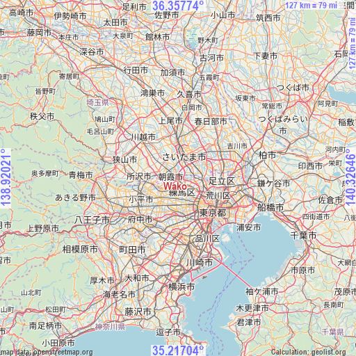
Wako GPS coordinates[2]
35° 47' 21.984" North, 139° 37' 23.988" East
| Map corner | latitude | longitude |
|---|---|---|
| Upper-left | 36.35774°, | 138.92021° |
| Center: | 35.78944°, | 139.62333° |
| Lower-right: | 35.21704°, | 140.32646° |
| Map W x H: | 126.8×126.8 km | = 78.8×78.8mi |
| max Lat: | 45.40944° ⇑38.3% North |
| Wako: | 35.78944° |
| min Lat: | ⇓61.7% South 24.34478° |
| min Long | Wako | max Long |
| 123° | 139.62333° | 145.575° |
| W 72%⇐ | ⇒28% E |
Elevation
Elevation of Wako is 24 m = 79 ft, and this is 60.6 m = 199 ft below average elevation for this country.
| Max E: |
1086 m = 3563 ft | 54% |
| Avg. | 84.6 m = 278 ft | |
| Wako | 24 m = 79 ft | |
Min E: |
-2 m = -7 ft | 46% |
See also: Wako elevation on elevation.city.
Geographical zone
Wako is located in North temperate zone (between Tropic of Cancer and the Arctic Circle). Distance of this Northern Tropic circle is 1373.5 km =853.5 mi to South.| Distance of | km | miles | from Wako |
|---|---|---|---|
| North Pole | 6027.6 | 3745.4 | to North |
| Arctic Circle | 3421.8 | 2126.2 | to North |
| Tropic Cancer | 1373.5 | 853.5 | to South |
| Equator | 3979.4 | 2472.7 | to South |


Nearby cities:
15 places around Wako: (largest is in red/bold)
• Asaka
2.6 km =1.6 mi,  311°
311°
• Fujimi
9 km =5.6 mi,  316°
316°
• Higashikurume
10.9 km =6.8 mi,  247°
247°
• Kawaguchi
8.1 km =5 mi,  77°
77°
• Kiyose
8.5 km =5.3 mi,  262°
262°
• Musashino
10.9 km =6.8 mi,  211°
211°
• Niiza
6.9 km =4.3 mi,  300°
300°
• Nishi-Tokyo-shi
10.5 km =6.5 mi,  227°
227°
• Nishitōkyō
9.2 km =5.7 mi, 227°
• Shiki
6.1 km =3.8 mi, 323°
• Shimotoda
6.3 km =3.9 mi,  63°
63°
• Tanashichō
10.2 km =6.3 mi, 228°
• Toda
4.3 km =2.7 mi,  50°
50°
• Warabi
6.7 km =4.2 mi, 57°
• Yono
10.5 km =6.5 mi,  4°
4°
Sources, notices
• [Note1] Compared only with cities in Japan existing in our database
• [Src1] Map data: © OpenStreetMap contributors (CC-BY-SA)
• [Src2] Other city data from geonames.org with taken over terms of usage.
• [Src3] Geographical zone / Annual Mean Temperature by Robert A. Rohde @ Wikipedia
