Niiza geodata
Niiza (Saitama) is a seat of a second-order administrative division; located in Japan in Asia/Tokyo (GMT+9) time zone. In our database, there are 767 cities with bigger population. Compared to other cities in Japan, 62.5% of cities are located further ↓South; 70.6% of cities are located further ←West and 68.3% of cities have higher elevation than Niiza. Note1


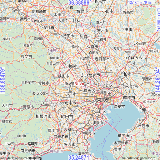
Niiza GPS coordinates[2]
35° 49' 15.168" North, 139° 33' 28.476" East
| Map corner | latitude | longitude |
|---|---|---|
| Upper-left | 36.38896°, | 138.85479° |
| Center: | 35.82088°, | 139.55791° |
| Lower-right: | 35.24871°, | 140.26104° |
| Map W x H: | 126.8×126.8 km | = 78.8×78.8mi |
| max Lat: | 45.40944° ⇑37.5% North |
| Niiza: | 35.82088° |
| min Lat: | ⇓62.5% South 24.34478° |
| min Long | Niiza | max Long |
| 123° | 139.55791° | 145.575° |
| W 70.6%⇐ | ⇒29.4% E |
Elevation
Elevation of Niiza is 13 m = 43 ft, and this is 71.6 m = 235 ft below average elevation for this country.
| Max E: |
1086 m = 3563 ft | 68.3% |
| Avg. | 84.6 m = 278 ft | |
| Niiza | 13 m = 43 ft | |
Min E: |
-2 m = -7 ft | 31.7% |
See also: Japan elevation on elevation.city.
Geographical zone
Niiza is located in North temperate zone (between Tropic of Cancer and the Arctic Circle). Distance of this Northern Tropic circle is 1377 km =855.6 mi to South.| Distance of | km | miles | from Niiza |
|---|---|---|---|
| North Pole | 6024.2 | 3743.3 | to North |
| Arctic Circle | 3418.3 | 2124 | to North |
| Tropic Cancer | 1377 | 855.6 | to South |
| Equator | 3982.9 | 2474.9 | to South |


Nearby cities:
15 places around Niiza: (largest is in red/bold)
• Asaka
4.4 km =2.7 mi,  114°
114°
• Fujimi
3 km =1.9 mi,  355°
355°
• Fujimino
5.9 km =3.7 mi,  319°
319°
• Higashikurume
8.7 km =5.4 mi,  208°
208°
• Kamifukuoka
7 km =4.3 mi,  325°
325°
• Kiyose
5.2 km =3.2 mi, 208°
• Nishi-Tokyo-shi
10.8 km =6.7 mi,  189°
189°
• Nishitōkyō
9.8 km =6.1 mi, 185°
• Shiki
2.7 km =1.7 mi,  58°
58°
• Tanashichō
10.3 km =6.4 mi, 189°
• Toda
9.2 km =5.7 mi,  94°
94°
• Tokorozawa
8.4 km =5.2 mi,  253°
253°
• Wako
6.9 km =4.3 mi,  120°
120°
• Yono
9.7 km =6 mi,  44°
44°
• Ōi
4.8 km =3 mi,  314°
314°
Sources, notices
• [Note1] Compared only with cities in Japan existing in our database
• [Src1] Map data: © OpenStreetMap contributors (CC-BY-SA)
• [Src2] Other city data from geonames.org with taken over terms of usage.
• [Src3] Geographical zone / Annual Mean Temperature by Robert A. Rohde @ Wikipedia
