Mandera geodata
Mandera is a seat of a first-order administrative division; located in Kenya in Africa/Nairobi (GMT+3) time zone. With population of 36,076 people, there are 25 cities with bigger population in this country. Compared to other cities in Kenya, 100% of cities are located further ↓South; 100% of cities are located further ←West and 87.7% of cities have higher elevation than Mandera. Note1


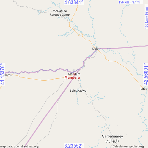
Mandera GPS coordinates[2]
3° 56' 14.136" North, 41° 51' 24.768" East
| Map corner | latitude | longitude |
|---|---|---|
| Upper-left | 4.63841°, | 41.15376° |
| Center: | 3.93726°, | 41.85688° |
| Lower-right: | 3.23552°, | 42.56001° |
| Map W x H: | 156×156 km | = 96.9×96.9mi |
| max Lat: | 3.93726° ⇑0% North |
| Mandera: | 3.93726° |
| min Lat: | ⇓100% South -4.64756° |
| min Long | Mandera | max Long |
| 33.97248° | 41.85688° | 41.85688° |
| W 100%⇐ | ⇒0% E |
Elevation
Elevation of Mandera is 217 m = 712 ft, and this is 1129.7 m = 3706 ft below average elevation for this country.
| Max E: |
2514 m = 8248 ft | 87.7% |
| Avg. | 1346.7 m = 4418 ft | |
| Mandera | 217 m = 712 ft | |
Min E: |
7 m = 23 ft | 12.3% |
See also: Kenya elevation on elevation.city.
Geographical zone
Mandera is located in North Torrid zone (between Equator and Tropic of Cancer). Distance of Equator is 437.8 km =272 mi to South.| Distance of | km | miles | from Mandera |
|---|---|---|---|
| North Pole | 9569.3 | 5946.1 | to North |
| Arctic Circle | 6963.4 | 4326.9 | to North |
| Tropic Cancer | 2168.1 | 1347.2 | to North |
| Equator | 437.8 | 272 | to South |


Nearby cities:
2 places around Mandera: (largest is in red/bold)
• Moyale
314.1 km =195.2 mi,  261°
261°
• Wajir
315 km =195.7 mi,  219°
219°
Sources, notices
• [Note1] Compared only with cities in Kenya existing in our database
• [Src1] Map data: © OpenStreetMap contributors (CC-BY-SA)
• [Src2] Other city data from geonames.org with taken over terms of usage.
• [Src3] Geographical zone / Annual Mean Temperature by Robert A. Rohde @ Wikipedia
