Wajir geodata
Wajir is a seat of a first-order administrative division; located in Kenya in Africa/Nairobi (GMT+3) time zone. With population of 45,771 people, there are 17 cities with bigger population in this country. Compared to other cities in Kenya, 96.5% of cities are located further ↓South; 95.6% of cities are located further ←West and 86.8% of cities have higher elevation than Wajir. Note1


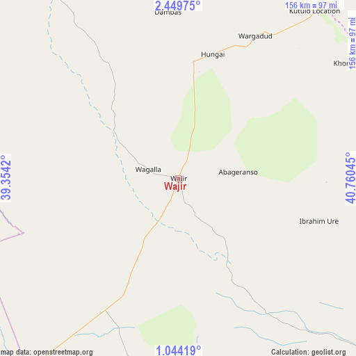
Wajir GPS coordinates[2]
1° 44' 49.56" North, 40° 3' 26.352" East
| Map corner | latitude | longitude |
|---|---|---|
| Upper-left | 2.44975°, | 39.3542° |
| Center: | 1.7471°, | 40.05732° |
| Lower-right: | 1.04419°, | 40.76045° |
| Map W x H: | 156.3×156.3 km | = 97.1×97.1mi |
| max Lat: | 3.93726° ⇑3.5% North |
| Wajir: | 1.7471° |
| min Lat: | ⇓96.5% South -4.64756° |
| min Long | Wajir | max Long |
| 33.97248° | 40.05732° | 41.85688° |
| W 95.6%⇐ | ⇒4.4% E |
Elevation
Elevation of Wajir is 258 m = 846 ft, and this is 1088.7 m = 3572 ft below average elevation for this country.
| Max E: |
2514 m = 8248 ft | 86.8% |
| Avg. | 1346.7 m = 4418 ft | |
| Wajir | 258 m = 846 ft | |
Min E: |
7 m = 23 ft | 13.2% |
See also: Wajir elevation on elevation.city.
Geographical zone
Wajir is located in North Torrid zone (between Equator and Tropic of Cancer). Distance of Equator is 194.3 km =120.7 mi to South.| Distance of | km | miles | from Wajir |
|---|---|---|---|
| North Pole | 9812.8 | 6097.4 | to North |
| Arctic Circle | 7206.9 | 4478.2 | to North |
| Tropic Cancer | 2411.7 | 1498.6 | to North |
| Equator | 194.3 | 120.7 | to South |


Nearby cities:
15 places around Wajir: (largest is in red/bold)
• Chuka
354.1 km =220 mi,  229°
229°
• Embu
385 km =239.2 mi, 228°
• Garissa
248.8 km =154.6 mi,  190°
190°
• Hola
359.1 km =223.1 mi,  180°
180°
• Isiolo
315.7 km =196.2 mi,  240°
240°
• Kathwana
335.6 km =208.5 mi, 226°
• Kerugoya
397.1 km =246.7 mi, 231°
• Mandera
315 km =195.7 mi,  39°
39°
• Maralal
380.3 km =236.3 mi,  259°
259°
• Marsabit
238.7 km =148.3 mi,  285°
285°
• Maua
289.3 km =179.8 mi, 234°
• Meru
327.2 km =203.3 mi, 234°
• Moyale
227 km =141.1 mi,  330°
330°
• Mwingi
371.9 km =231.1 mi,  216°
216°
• Nanyuki
384 km =238.6 mi, 239°
Sources, notices
• [Note1] Compared only with cities in Kenya existing in our database
• [Src1] Map data: © OpenStreetMap contributors (CC-BY-SA)
• [Src2] Other city data from geonames.org with taken over terms of usage.
• [Src3] Geographical zone / Annual Mean Temperature by Robert A. Rohde @ Wikipedia
