Prey Veng geodata
Prey Veng is a seat of a first-order administrative division; located in Cambodia in Asia/Phnom_Penh (GMT+7) time zone. With population of 33,079 people, there are 13 cities with bigger population in this country. Compared to other cities in Cambodia, 72% of cities are located further ↑North; 76.5% of cities are located further ←West and 77.3% of cities have higher elevation than Prey Veng. Note1


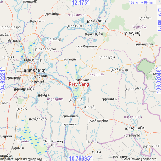
Prey Veng GPS coordinates[2]
11° 29' 12.552" North, 105° 19' 31.188" East
| Map corner | latitude | longitude |
|---|---|---|
| Upper-left | 12.175°, | 104.62221° |
| Center: | 11.48682°, | 105.32533° |
| Lower-right: | 10.79695°, | 106.02846° |
| Map W x H: | 153.2×153.2 km | = 95.2×95.2mi |
| max Lat: | 14.23223° ⇑72% North |
| Prey Veng: | 11.48682° |
| min Lat: | ⇓28% South 10.48291° |
| min Long | Prey Veng | max Long |
| 102.37574° | 105.32533° | 107.42393° |
| W 76.5%⇐ | ⇒23.5% E |
Elevation
Elevation of Prey Veng is 13 m = 43 ft, and this is 39 m = 128 ft below average elevation for this country.
| Max E: |
678 m = 2224 ft | 77.3% |
| Avg. | 52 m = 171 ft | |
| Prey Veng | 13 m = 43 ft | |
Min E: |
4 m = 13 ft | 22.7% |
See also: Cambodia elevation on elevation.city.
Geographical zone
Prey Veng is located in North Torrid zone (between Equator and Tropic of Cancer). Distance of Equator is 1277.2 km =793.6 mi to South.| Distance of | km | miles | from Prey Veng |
|---|---|---|---|
| North Pole | 8729.8 | 5424.4 | to North |
| Arctic Circle | 6124 | 3805.3 | to North |
| Tropic Cancer | 1328.7 | 825.6 | to North |
| Equator | 1277.2 | 793.6 | to South |


Nearby cities:
15 places around Prey Veng: (largest is in red/bold)
• Kampong Leav
2.1 km =1.3 mi,  70°
70°
• Kampong Trabaek
41.8 km =26 mi,  155°
155°
• Kaoh Soutin
45.7 km =28.4 mi,  14°
14°
• Leuk Daek
36.2 km =22.5 mi,  196°
196°
• Me Sang
29.9 km =18.6 mi,  126°
126°
• Mean Chey
42.7 km =26.5 mi,  276°
276°
• Peam Chor
44.6 km =27.7 mi,  194°
194°
• Peam Ro
20.3 km =12.6 mi, 192°
• Phnom Penh
45.4 km =28.2 mi, 280°
• Preah Sdach
44 km =27.3 mi,  171°
171°
• Prey Veaeng
14 km =8.7 mi,  47°
47°
• Sithor Kandal
32.4 km =20.1 mi, 11°
• S’ang
37.3 km =23.2 mi,  247°
247°
• Ta Khmau
40.9 km =25.4 mi,  269°
269°
• Ta Khmau
41.6 km =25.8 mi,  263°
263°
Sources, notices
• [Note1] Compared only with cities in Cambodia existing in our database
• [Src1] Map data: © OpenStreetMap contributors (CC-BY-SA)
• [Src2] Other city data from geonames.org with taken over terms of usage.
• [Src3] Geographical zone / Annual Mean Temperature by Robert A. Rohde @ Wikipedia
