Kampong Leav geodata
Kampong Leav (Prey Veng) is a seat of a second-order administrative division; located in Cambodia in Asia/Phnom_Penh (GMT+7) time zone. In our database, there are 29 cities with bigger population. Compared to other cities in Cambodia, 71.2% of cities are located further ↑North; 77.3% of cities are located further ←West and 85.6% of cities have higher elevation than Kampong Leav. Note1


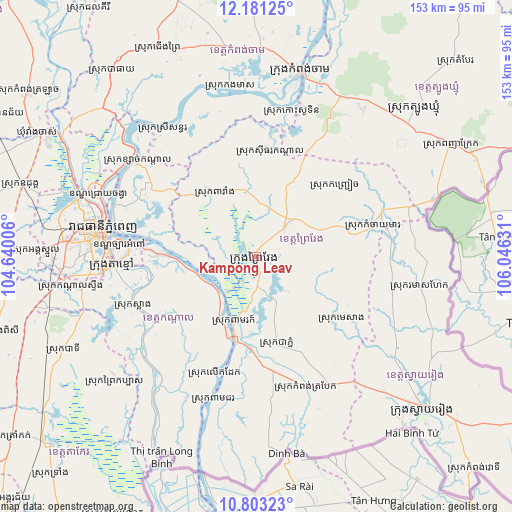
Kampong Leav GPS coordinates[2]
11° 29' 35.088" North, 105° 20' 35.448" East
| Map corner | latitude | longitude |
|---|---|---|
| Upper-left | 12.18125°, | 104.64006° |
| Center: | 11.49308°, | 105.34318° |
| Lower-right: | 10.80323°, | 106.04631° |
| Map W x H: | 153.2×153.2 km | = 95.2×95.2mi |
| max Lat: | 14.23223° ⇑71.2% North |
| Kampong Leav: | 11.49308° |
| min Lat: | ⇓28.8% South 10.48291° |
| min Long | Kampong Leav | max Long |
| 102.37574° | 105.34318° | 107.42393° |
| W 77.3%⇐ | ⇒22.7% E |
Elevation
Elevation of Kampong Leav is 9 m = 30 ft, and this is 43 m = 141 ft below average elevation for this country.
| Max E: |
678 m = 2224 ft | 85.6% |
| Avg. | 52 m = 171 ft | |
| Kampong Leav | 9 m = 30 ft | |
Min E: |
4 m = 13 ft | 14.4% |
See also: Cambodia elevation on elevation.city.
Geographical zone
Kampong Leav is located in North Torrid zone (between Equator and Tropic of Cancer). Distance of Equator is 1277.9 km =794.1 mi to South.| Distance of | km | miles | from Kampong Leav |
|---|---|---|---|
| North Pole | 8729.2 | 5424.1 | to North |
| Arctic Circle | 6123.3 | 3804.8 | to North |
| Tropic Cancer | 1328 | 825.2 | to North |
| Equator | 1277.9 | 794.1 | to South |


Nearby cities:
15 places around Kampong Leav: (largest is in red/bold)
• Kampong Trabaek
41.7 km =25.9 mi,  158°
158°
• Kaoh Soutin
44.6 km =27.7 mi,  11°
11°
• Leuk Daek
37.5 km =23.3 mi,  199°
199°
• Me Sang
28.8 km =17.9 mi,  129°
129°
• Mean Chey
44.5 km =27.7 mi,  275°
275°
• Peam Chor
45.8 km =28.5 mi, 196°
• Peam Ro
21.5 km =13.4 mi, 197°
• Phnom Penh
47.2 km =29.3 mi, 279°
• Preah Sdach
44.5 km =27.7 mi,  174°
174°
• Prey Veaeng
12.1 km =7.5 mi,  44°
44°
• Prey Veng
2.1 km =1.3 mi,  250°
250°
• Sithor Kandal
31.4 km =19.5 mi, 7°
• S’ang
39.4 km =24.5 mi, 248°
• Ta Khmau
42.9 km =26.7 mi,  268°
268°
• Ta Khmau
43.6 km =27.1 mi,  263°
263°
Sources, notices
• [Note1] Compared only with cities in Cambodia existing in our database
• [Src1] Map data: © OpenStreetMap contributors (CC-BY-SA)
• [Src2] Other city data from geonames.org with taken over terms of usage.
• [Src3] Geographical zone / Annual Mean Temperature by Robert A. Rohde @ Wikipedia
