Moya geodata
Moya (Anjouan) is a populated place; located in Comoros in Indian/Comoro (GMT+3) time zone. With population of 7,529 people, there are 10 cities with bigger population in this country. Compared to other cities in Comoros, 90.3% of cities are located further ↑North; 81.4% of cities are located further ←West and 50.4% of cities have higher elevation than Moya. Note1


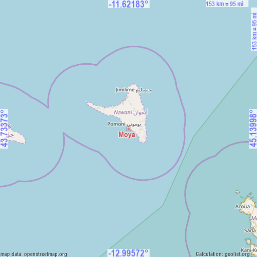
Moya GPS coordinates[2]
12° 18' 34.812" South, 44° 26' 12.66" East
| Map corner | latitude | longitude |
|---|---|---|
| Upper-left | -11.62183°, | 43.73373° |
| Center: | -12.30967°, | 44.43685° |
| Lower-right: | -12.99572°, | 45.13998° |
| Map W x H: | 152.8×152.8 km | = 94.9×94.9mi |
| max Lat: | -11.38472° ⇑90.3% North |
| Moya: | -12.30967° |
| min Lat: | ⇓9.7% South -12.37306° |
| min Long | Moya | max Long |
| 43.2525° | 44.43685° | 44.53194° |
| W 81.4%⇐ | ⇒18.6% E |
Elevation
Elevation of Moya is 142 m = 466 ft, and this is 54.1 m = 177 ft below average elevation for this country.
| Max E: |
924 m = 3031 ft | 50.4% |
| Avg. | 196.1 m = 643 ft | |
| Moya | 142 m = 466 ft | |
Min E: |
1 m = 3 ft | 49.6% |
See also: Comoros elevation on elevation.city.
Geographical zone
Moya is located in South Torrid zone (between Equator and Tropic of Capricorn). Distance of this Southern Tropic circle is 1237.2 km =768.8 mi to South.| Distance of | km | miles | from Moya |
|---|---|---|---|
| Equator | 1368.7 | 850.5 | to North |
| Tropic Capricorn | 1237.2 | 768.8 | to South |
| Antarctic Circle | 6032.5 | 3748.4 | to South |
| South Pole | 8638.4 | 5367.7 | to South |


Nearby cities:
15 places around Moya: (largest is in red/bold)
• Adda-Douéni
6.8 km =4.2 mi,  73°
73°
• Antsahé
10.7 km =6.6 mi,  119°
119°
• Daji
5.9 km =3.7 mi,  107°
107°
• Kangani
4.1 km =2.5 mi, 107°
• Koni-Djodjo
10.1 km =6.3 mi,  28°
28°
• Koni-Ngani
11.4 km =7.1 mi,  24°
24°
• Kyo
9.3 km =5.8 mi, 105°
• Limbi
10.8 km =6.7 mi,  43°
43°
• Lingoni
6.3 km =3.9 mi,  341°
341°
• Magnassini-Nindri
4.2 km =2.6 mi,  326°
326°
• Mramani
10.8 km =6.7 mi, 112°
• Mrémani
6.7 km =4.2 mi,  88°
88°
• Ouzini
6.6 km =4.1 mi, 44°
• Tsimbeo
11.9 km =7.4 mi,  14°
14°
• Vouani
10 km =6.2 mi,  317°
317°
Sources, notices
• [Note1] Compared only with cities in Comoros existing in our database
• [Src1] Map data: © OpenStreetMap contributors (CC-BY-SA)
• [Src2] Other city data from geonames.org with taken over terms of usage.
• [Src3] Geographical zone / Annual Mean Temperature by Robert A. Rohde @ Wikipedia
