Suncheon geodata
Suncheon (Jeollanam-do) is a seat of a second-order administrative division; located in South Korea in Asia/Seoul (GMT+9) time zone. With population of 230,796 people, there are 31 cities with bigger population in this country. Compared to other cities in South Korea, 83.9% of cities are located further ↑North; 59.1% of cities are located further ←West and 95.1% of cities have higher elevation than Suncheon. Note1


Suncheon GPS coordinates[2]
34° 57' 1.8" North, 127° 29' 16.224" East
| Map corner | latitude | longitude |
|---|---|---|
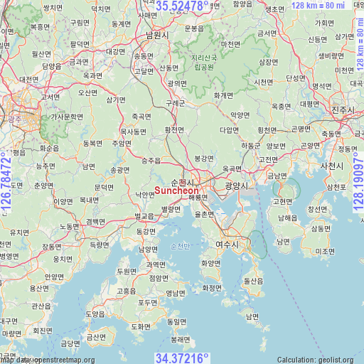
| Upper-left | 35.52478°, | 126.78472° |
| Center: | 34.9505°, | 127.48784° |
| Lower-right: | 34.37216°, | 128.19097° |
| Map W x H: | 128.2×128.2 km | = 79.7×79.7mi |
| max Lat: | 38.37881° ⇑83.9% North |
| Suncheon: | 34.9505° |
| min Lat: | ⇓16.1% South 33.25333° |
| min Long | Suncheon | max Long |
| 126.10863° | 127.48784° | 129.55377° |
| W 59.1%⇐ | ⇒40.9% E |
Elevation
Elevation of Suncheon is 7 m = 23 ft, and this is 63.4 m = 208 ft below average elevation for this country.
| Max E: |
691 m = 2267 ft | 95.1% |
| Avg. | 70.4 m = 231 ft | |
| Suncheon | 7 m = 23 ft | |
Min E: |
1 m = 3 ft | 4.9% |
See also: Suncheon elevation on elevation.city.
Geographical zone
Suncheon is located in North temperate zone (between Tropic of Cancer and the Arctic Circle). Distance of this Northern Tropic circle is 1280.2 km =795.5 mi to South.| Distance of | km | miles | from Suncheon |
|---|---|---|---|
| North Pole | 6120.9 | 3803.3 | to North |
| Arctic Circle | 3515 | 2184.1 | to North |
| Tropic Cancer | 1280.2 | 795.5 | to South |
| Equator | 3886.1 | 2414.7 | to South |


Nearby cities:
15 places around Suncheon: (largest is in red/bold)
• Beolgyo
17.5 km =10.9 mi,  229°
229°
• Bonggang
10.9 km =6.8 mi,  51°
51°
• Byeollyang
9 km =5.6 mi,  201°
201°
• Gwangyang
19 km =11.8 mi,  93°
93°
• Haeryong
6.1 km =3.8 mi,  131°
131°
• Jinsang
22.5 km =14 mi,  69°
69°
• Kwangyang
9.6 km =6 mi, 73°
• Oeseo
19.6 km =12.2 mi,  258°
258°
• Okgok
19.7 km =12.2 mi,  77°
77°
• Ongnyong
14.1 km =8.8 mi,  58°
58°
• Sangsa
3.2 km =2 mi,  247°
247°
• Seungju
11.5 km =7.1 mi,  308°
308°
• Songgwang
20.6 km =12.8 mi,  277°
277°
• Sora
21.9 km =13.6 mi,  142°
142°
• Yulchon
11.2 km =7 mi, 132°
Sources, notices
• [Note1] Compared only with cities in South Korea existing in our database
• [Src1] Map data: © OpenStreetMap contributors (CC-BY-SA)
• [Src2] Other city data from geonames.org with taken over terms of usage.
• [Src3] Geographical zone / Annual Mean Temperature by Robert A. Rohde @ Wikipedia
