Kwangyang geodata
Kwangyang (Jeollanam-do) is a populated place; located in South Korea in Asia/Seoul (GMT+9) time zone. With population of 89,281 people, there are 51 cities with bigger population in this country. Compared to other cities in South Korea, 82.5% of cities are located further ↑North; 64.7% of cities are located further ←West and 80.8% of cities have higher elevation than Kwangyang. Note1


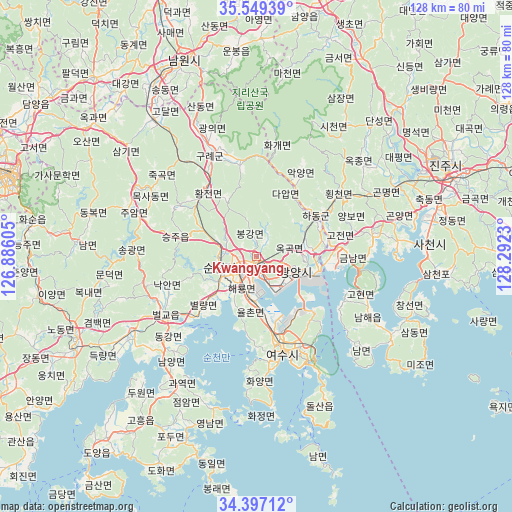
Kwangyang GPS coordinates[2]
34° 58' 31.008" North, 127° 35' 21.012" East
| Map corner | latitude | longitude |
|---|---|---|
| Upper-left | 35.54939°, | 126.88605° |
| Center: | 34.97528°, | 127.58917° |
| Lower-right: | 34.39712°, | 128.2923° |
| Map W x H: | 128.1×128.1 km | = 79.6×79.6mi |
| max Lat: | 38.37881° ⇑82.5% North |
| Kwangyang: | 34.97528° |
| min Lat: | ⇓17.5% South 33.25333° |
| min Long | Kwangyang | max Long |
| 126.10863° | 127.58917° | 129.55377° |
| W 64.7%⇐ | ⇒35.3% E |
Elevation
Elevation of Kwangyang is 16 m = 52 ft, and this is 54.4 m = 178 ft below average elevation for this country.
| Max E: |
691 m = 2267 ft | 80.8% |
| Avg. | 70.4 m = 231 ft | |
| Kwangyang | 16 m = 52 ft | |
Min E: |
1 m = 3 ft | 19.2% |
See also: Kwangyang elevation on elevation.city.
Geographical zone
Kwangyang is located in North temperate zone (between Tropic of Cancer and the Arctic Circle). Distance of this Northern Tropic circle is 1283 km =797.2 mi to South.| Distance of | km | miles | from Kwangyang |
|---|---|---|---|
| North Pole | 6118.2 | 3801.7 | to North |
| Arctic Circle | 3512.3 | 2182.4 | to North |
| Tropic Cancer | 1283 | 797.2 | to South |
| Equator | 3888.9 | 2416.4 | to South |


Nearby cities:
15 places around Kwangyang: (largest is in red/bold)
• Bonggang
4.1 km =2.5 mi,  349°
349°
• Byeollyang
16.8 km =10.4 mi,  228°
228°
• Geumseong
18.4 km =11.4 mi,  93°
93°
• Gwangyang
10.4 km =6.5 mi,  111°
111°
• Hadong
18 km =11.2 mi,  55°
55°
• Haeryong
8.3 km =5.2 mi,  214°
214°
• Jinsang
12.9 km =8 mi,  66°
66°
• Jinwol
15.4 km =9.6 mi, 88°
• Okgok
10.1 km =6.3 mi,  80°
80°
• Ongnyong
5.5 km =3.4 mi,  30°
30°
• Sangsa
12.8 km =8 mi,  251°
251°
• Seungju
18.7 km =11.6 mi,  283°
283°
• Sora
20.6 km =12.8 mi,  168°
168°
• Suncheon
9.6 km =6 mi, 253°
• Yulchon
10.4 km =6.5 mi,  185°
185°
Sources, notices
• [Note1] Compared only with cities in South Korea existing in our database
• [Src1] Map data: © OpenStreetMap contributors (CC-BY-SA)
• [Src2] Other city data from geonames.org with taken over terms of usage.
• [Src3] Geographical zone / Annual Mean Temperature by Robert A. Rohde @ Wikipedia
