Okcheon geodata
Okcheon (North Chungcheong) is a populated place; located in South Korea in Asia/Seoul (GMT+9) time zone. With population of 56,634 people, there are 78 cities with bigger population in this country. Compared to other cities in South Korea, 60.1% of cities are located further ↓South; 63.3% of cities are located further ←West and 77.3% of cities have lower elevation than Okcheon. Note1


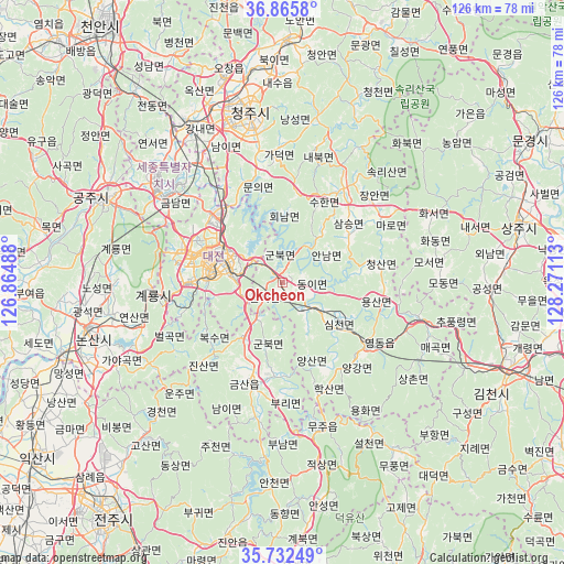
Okcheon GPS coordinates[2]
36° 18' 4.32" North, 127° 34' 4.8" East
| Map corner | latitude | longitude |
|---|---|---|
| Upper-left | 36.8658°, | 126.86488° |
| Center: | 36.3012°, | 127.568° |
| Lower-right: | 35.73249°, | 128.27113° |
| Map W x H: | 126×126 km | = 78.3×78.3mi |
| max Lat: | 38.37881° ⇑39.9% North |
| Okcheon: | 36.3012° |
| min Lat: | ⇓60.1% South 33.25333° |
| min Long | Okcheon | max Long |
| 126.10863° | 127.568° | 129.55377° |
| W 63.3%⇐ | ⇒36.7% E |
Elevation
Elevation of Okcheon is 97 m = 318 ft, and this is 26.6 m = 87 ft above average elevation for this country.
| Max E: |
691 m = 2267 ft | 22.7% |
| Okcheon | 97 m 318 ft | |
| Avg. | 70.4 m = 231 ft | |
Min E: |
1 m = 3 ft | 77.3% |
See also: Okcheon elevation on elevation.city.
Geographical zone
Okcheon is located in North temperate zone (between Tropic of Cancer and the Arctic Circle). Distance of this Northern Tropic circle is 1430.4 km =888.8 mi to South.| Distance of | km | miles | from Okcheon |
|---|---|---|---|
| North Pole | 5970.7 | 3710 | to North |
| Arctic Circle | 3364.9 | 2090.9 | to North |
| Tropic Cancer | 1430.4 | 888.8 | to South |
| Equator | 4036.3 | 2508 | to South |


Nearby cities:
15 places around Okcheon: (largest is in red/bold)
• Annae
13.3 km =8.3 mi,  38°
38°
• Annam
11.2 km =7 mi,  56°
56°
• Cheongsan
20.8 km =12.9 mi,  75°
75°
• Cheongseong
17.4 km =10.8 mi, 80°
• Daejeon
17.2 km =10.7 mi,  288°
288°
• Dongi
5 km =3.1 mi,  111°
111°
• Gunbuk
4.5 km =2.8 mi,  316°
316°
• Gunbuk
15.3 km =9.5 mi,  193°
193°
• Gunseo
4.4 km =2.7 mi,  236°
236°
• Hoenam
16 km =9.9 mi,  3°
3°
• Iwon
7.7 km =4.8 mi,  142°
142°
• Samseung
18.1 km =11.2 mi,  54°
54°
• Simcheon
15.6 km =9.7 mi,  117°
117°
• Sintansin
20.9 km =13 mi, 324°
• Yuseong
21.5 km =13.4 mi, 285°
Sources, notices
• [Note1] Compared only with cities in South Korea existing in our database
• [Src1] Map data: © OpenStreetMap contributors (CC-BY-SA)
• [Src2] Other city data from geonames.org with taken over terms of usage.
• [Src3] Geographical zone / Annual Mean Temperature by Robert A. Rohde @ Wikipedia
