Lavoriškės geodata
Lavoriškės is a populated place; located in Lithuania in Europe/Vilnius (GMT+3) time zone. With population of 585 people, there are 133 cities with bigger population in this country. Compared to other cities in Lithuania, 76.9% of cities are located further ↑North; 94% of cities are located further ←West and 86.6% of cities have lower elevation than Lavoriškės. Note1


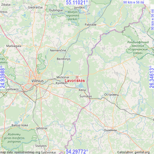
Lavoriškės GPS coordinates[2]
54° 42' 21.6" North, 25° 38' 34.8" East
| Map corner | latitude | longitude |
|---|---|---|
| Upper-left | 55.11021°, | 24.93988° |
| Center: | 54.706°, | 25.643° |
| Lower-right: | 54.29772°, | 26.34613° |
| Map W x H: | 90.3×90.3 km | = 56.1×56.1mi |
| max Lat: | 56.36149° ⇑76.9% North |
| Lavoriškės: | 54.706° |
| min Lat: | ⇓23.1% South 54.01573° |
| min Long | Lavoriškės | max Long |
| 20.99651° | 25.643° | 26.43984° |
| W 94%⇐ | ⇒6% E |
Elevation
Elevation of Lavoriškės is 156 m = 512 ft, and this is 65.3 m = 214 ft above average elevation for this country.
| Max E: |
204 m = 669 ft | 13.4% |
| Lavoriškės | 156 m 512 ft | |
| Avg. | 90.7 m = 298 ft | |
Min E: |
-1 m = -3 ft | 86.6% |
See also: Lithuania elevation on elevation.city.
Geographical zone
Lavoriškės is located in North temperate zone (between Tropic of Cancer and the Arctic Circle). Distance of this North polar circle is 1318.4 km =819.2 mi to North.| Distance of | km | miles | from Lavoriškės |
|---|---|---|---|
| North Pole | 3924.3 | 2438.4 | to North |
| Arctic Circle | 1318.4 | 819.2 | to North |
| Tropic Cancer | 3476.8 | 2160.4 | to South |
| Equator | 6082.7 | 3779.6 | to South |


Nearby cities:
15 places around Lavoriškės: (largest is in red/bold)
• Baltoji Vokė
31.2 km =19.4 mi,  247°
247°
• Fabijoniškės
26 km =16.2 mi,  276°
276°
• Grigiškės
36.1 km =22.4 mi,  265°
265°
• Justiniškės
27.4 km =17 mi, 272°
• Lazdynai
28.3 km =17.6 mi,  261°
261°
• Naujamiestis
24.2 km =15 mi, 263°
• Nemenčinė
19.3 km =12 mi,  324°
324°
• Pabradė
31.5 km =19.6 mi,  13°
13°
• Pašilaičiai
27.4 km =17 mi, 276°
• Pilaitė
29.5 km =18.3 mi, 268°
• Rasos
21.5 km =13.4 mi, 261°
• Skaidiškės
18.9 km =11.7 mi,  237°
237°
• Vilkpėdė
25.7 km =16 mi, 260°
• Vilnius
23.4 km =14.5 mi, 265°
• Šeškinė
25.2 km =15.7 mi, 270°
Sources, notices
• [Note1] Compared only with cities in Lithuania existing in our database
• [Src1] Map data: © OpenStreetMap contributors (CC-BY-SA)
• [Src2] Other city data from geonames.org with taken over terms of usage.
• [Src3] Geographical zone / Annual Mean Temperature by Robert A. Rohde @ Wikipedia
