Tetovo geodata
Tetovo is a seat of a first-order administrative division; located in North Macedonia in Europe/Skopje (GMT+2) time zone. With population of 72,944 people, there are 4 cities with bigger population in this country. Compared to other cities in North Macedonia, 86.5% of cities are located further ↓South; 87.2% of cities are located further →East and 63.6% of cities have higher elevation than Tetovo. Note1


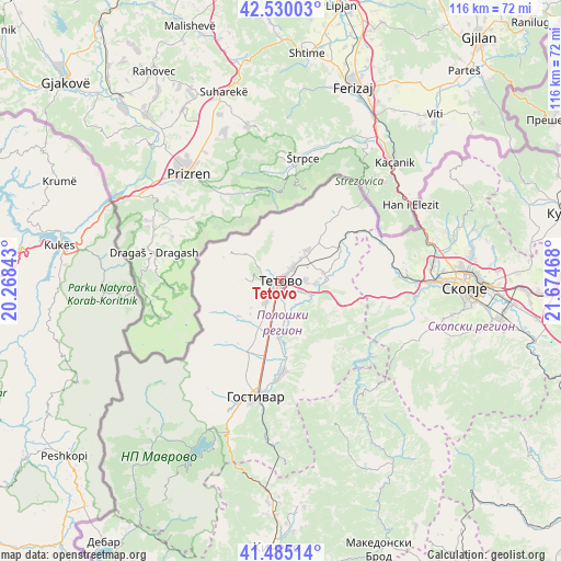
Tetovo GPS coordinates[2]
42° 0' 35.028" North, 20° 58' 17.58" East
| Map corner | latitude | longitude |
|---|---|---|
| Upper-left | 42.53003°, | 20.26843° |
| Center: | 42.00973°, | 20.97155° |
| Lower-right: | 41.48514°, | 21.67468° |
| Map W x H: | 116.2×116.2 km | = 72.2×72.2mi |
| max Lat: | 42.23276° ⇑13.5% North |
| Tetovo: | 42.00973° |
| min Lat: | ⇓86.5% South 40.87556° |
| min Long | Tetovo | max Long |
| 20.52421° | 20.97155° | 22.95624° |
| W 12.8%⇐ | ⇒87.2% E |
Elevation
Elevation of Tetovo is 466 m = 1529 ft, and this is 73.7 m = 242 ft below average elevation for this country.
| Max E: |
1382 m = 4534 ft | 63.6% |
| Avg. | 539.7 m = 1771 ft | |
| Tetovo | 466 m = 1529 ft | |
Min E: |
62 m = 203 ft | 36.4% |
See also: Tetovo elevation on elevation.city.
Geographical zone
Tetovo is located in North temperate zone (between Tropic of Cancer and the Arctic Circle). Distance of this Northern Tropic circle is 2065.1 km =1283.2 mi to South.| Distance of | km | miles | from Tetovo |
|---|---|---|---|
| North Pole | 5336 | 3315.6 | to North |
| Arctic Circle | 2730.1 | 1696.4 | to North |
| Tropic Cancer | 2065.1 | 1283.2 | to South |
| Equator | 4671 | 2902.4 | to South |


Nearby cities:
15 places around Tetovo: (largest is in red/bold)
• Brvenica
4.8 km =3 mi,  170°
170°
• Dolna Lešnica
9.4 km =5.8 mi,  128°
128°
• Dolno Palčište
5.8 km =3.6 mi,  217°
217°
• Džepčište
3.4 km =2.1 mi,  40°
40°
• Fališe
4.3 km =2.7 mi,  137°
137°
• Golema Rečica
3.3 km =2.1 mi, 222°
• Kamenjane
7.9 km =4.9 mi,  206°
206°
• Poroj
2.8 km =1.7 mi, 38°
• Saračino
6.6 km =4.1 mi,  118°
118°
• Selce
3.8 km =2.4 mi,  317°
317°
• Slatino
8.5 km =5.3 mi, 40°
• Strimnica
7.1 km =4.4 mi, 131°
• Zelino
8.3 km =5.2 mi,  113°
113°
• Čelopek
9.3 km =5.8 mi,  158°
158°
• Šipkovica
5.4 km =3.4 mi,  301°
301°
Sources, notices
• [Note1] Compared only with cities in North Macedonia existing in our database
• [Src1] Map data: © OpenStreetMap contributors (CC-BY-SA)
• [Src2] Other city data from geonames.org with taken over terms of usage.
• [Src3] Geographical zone / Annual Mean Temperature by Robert A. Rohde @ Wikipedia
