Brvenica geodata
Brvenica is a seat of a first-order administrative division; located in North Macedonia in Europe/Skopje (GMT+2) time zone. With population of 16,267 people, there are 35 cities with bigger population in this country. Compared to other cities in North Macedonia, 78.1% of cities are located further ↓South; 86.5% of cities are located further →East and 66.3% of cities have higher elevation than Brvenica. Note1


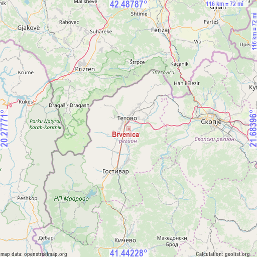
Brvenica GPS coordinates[2]
41° 58' 1.992" North, 20° 58' 50.988" East
| Map corner | latitude | longitude |
|---|---|---|
| Upper-left | 42.48787°, | 20.27771° |
| Center: | 41.96722°, | 20.98083° |
| Lower-right: | 41.44228°, | 21.68396° |
| Map W x H: | 116.3×116.3 km | = 72.3×72.3mi |
| max Lat: | 42.23276° ⇑21.9% North |
| Brvenica: | 41.96722° |
| min Lat: | ⇓78.1% South 40.87556° |
| min Long | Brvenica | max Long |
| 20.52421° | 20.98083° | 22.95624° |
| W 13.5%⇐ | ⇒86.5% E |
Elevation
Elevation of Brvenica is 435 m = 1427 ft, and this is 104.7 m = 344 ft below average elevation for this country.
| Max E: |
1382 m = 4534 ft | 66.3% |
| Avg. | 539.7 m = 1771 ft | |
| Brvenica | 435 m = 1427 ft | |
Min E: |
62 m = 203 ft | 33.7% |
See also: North Macedonia elevation on elevation.city.
Geographical zone
Brvenica is located in North temperate zone (between Tropic of Cancer and the Arctic Circle). Distance of this Northern Tropic circle is 2060.4 km =1280.3 mi to South.| Distance of | km | miles | from Brvenica |
|---|---|---|---|
| North Pole | 5340.7 | 3318.6 | to North |
| Arctic Circle | 2734.9 | 1699.4 | to North |
| Tropic Cancer | 2060.4 | 1280.3 | to South |
| Equator | 4666.3 | 2899.5 | to South |


Nearby cities:
15 places around Brvenica: (largest is in red/bold)
• Bogovinje
7.4 km =4.6 mi,  228°
228°
• Dolna Lešnica
6.7 km =4.2 mi,  100°
100°
• Dolno Palčište
4.3 km =2.7 mi,  272°
272°
• Džepčište
7.4 km =4.6 mi,  11°
11°
• Fališe
2.6 km =1.6 mi,  54°
54°
• Golema Rečica
3.7 km =2.3 mi,  308°
308°
• Kamenjane
4.9 km =3 mi,  240°
240°
• Miletino
7.2 km =4.5 mi,  156°
156°
• Poroj
7 km =4.3 mi, 8°
• Saračino
5.3 km =3.3 mi,  72°
72°
• Selce
8.2 km =5.1 mi,  336°
336°
• Strimnica
4.6 km =2.9 mi,  90°
90°
• Tetovo
4.8 km =3 mi,  350°
350°
• Zelino
7 km =4.3 mi,  78°
78°
• Čelopek
4.8 km =3 mi,  145°
145°
Sources, notices
• [Note1] Compared only with cities in North Macedonia existing in our database
• [Src1] Map data: © OpenStreetMap contributors (CC-BY-SA)
• [Src2] Other city data from geonames.org with taken over terms of usage.
• [Src3] Geographical zone / Annual Mean Temperature by Robert A. Rohde @ Wikipedia
