Struga geodata
Struga is a seat of a first-order administrative division; located in North Macedonia in Europe/Skopje (GMT+2) time zone. With population of 37,387 people, there are 15 cities with bigger population in this country. Compared to other cities in North Macedonia, 84.5% of cities are located further ↑North; 97% of cities are located further →East and 77.8% of cities have lower elevation than Struga. Note1


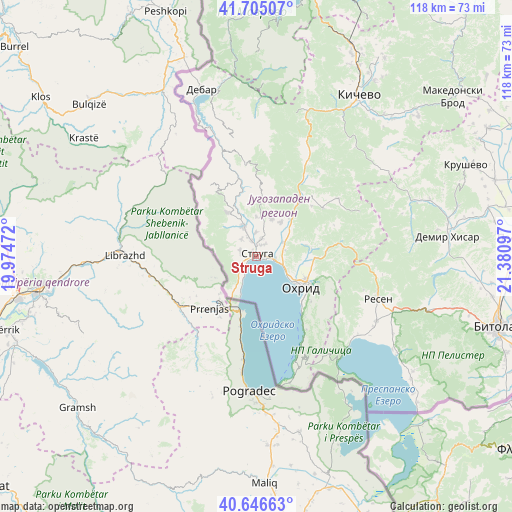
Struga GPS coordinates[2]
41° 10' 40.764" North, 20° 40' 40.224" East
| Map corner | latitude | longitude |
|---|---|---|
| Upper-left | 41.70507°, | 19.97472° |
| Center: | 41.17799°, | 20.67784° |
| Lower-right: | 40.64663°, | 21.38097° |
| Map W x H: | 117.7×117.7 km | = 73.1×73.1mi |
| max Lat: | 42.23276° ⇑84.5% North |
| Struga: | 41.17799° |
| min Lat: | ⇓15.5% South 40.87556° |
| min Long | Struga | max Long |
| 20.52421° | 20.67784° | 22.95624° |
| W 3%⇐ | ⇒97% E |
Elevation
Elevation of Struga is 696 m = 2283 ft, and this is 156.3 m = 513 ft above average elevation for this country.
| Max E: |
1382 m = 4534 ft | 22.2% |
| Struga | 696 m 2283 ft | |
| Avg. | 539.7 m = 1771 ft | |
Min E: |
62 m = 203 ft | 77.8% |
See also: North Macedonia elevation on elevation.city.
Geographical zone
Struga is located in North temperate zone (between Tropic of Cancer and the Arctic Circle). Distance of this Northern Tropic circle is 1972.6 km =1225.7 mi to South.| Distance of | km | miles | from Struga |
|---|---|---|---|
| North Pole | 5428.5 | 3373.1 | to North |
| Arctic Circle | 2822.6 | 1753.9 | to North |
| Tropic Cancer | 1972.6 | 1225.7 | to South |
| Equator | 4578.6 | 2845 | to South |


Nearby cities:
15 places around Struga: (largest is in red/bold)
• Belčišta
18.8 km =11.7 mi,  42°
42°
• Delogožda
9.6 km =6 mi,  22°
22°
• Gorna Bela Crkva
32.6 km =20.3 mi,  115°
115°
• Jankovec
28.9 km =18 mi,  105°
105°
• Kosel
13.2 km =8.2 mi,  91°
91°
• Labunista
12.2 km =7.6 mi,  325°
325°
• Lukovo
20.4 km =12.7 mi,  342°
342°
• Mešeišta
10.5 km =6.5 mi,  50°
50°
• Mislesevo
2.7 km =1.7 mi,  73°
73°
• Ohrid
12.4 km =7.7 mi, 123°
• Oktisi
8.5 km =5.3 mi,  315°
315°
• Radolista
4.8 km =3 mi,  251°
251°
• Resen
29.6 km =18.4 mi, 109°
• Velesta
7.5 km =4.7 mi, 337°
• Vevčani
9.9 km =6.2 mi,  314°
314°
Sources, notices
• [Note1] Compared only with cities in North Macedonia existing in our database
• [Src1] Map data: © OpenStreetMap contributors (CC-BY-SA)
• [Src2] Other city data from geonames.org with taken over terms of usage.
• [Src3] Geographical zone / Annual Mean Temperature by Robert A. Rohde @ Wikipedia
