Ohrid geodata
Ohrid is a seat of a first-order administrative division; located in North Macedonia in Europe/Skopje (GMT+2) time zone. With population of 54,908 people, there are 8 cities with bigger population in this country. Compared to other cities in North Macedonia, 89.2% of cities are located further ↑North; 95.3% of cities are located further →East and 79.1% of cities have lower elevation than Ohrid. Note1


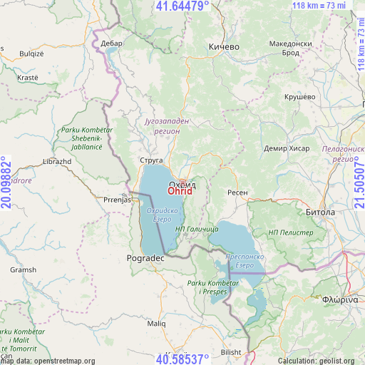
Ohrid GPS coordinates[2]
41° 7' 1.992" North, 20° 48' 6.984" East
| Map corner | latitude | longitude |
|---|---|---|
| Upper-left | 41.64479°, | 20.09882° |
| Center: | 41.11722°, | 20.80194° |
| Lower-right: | 40.58537°, | 21.50507° |
| Map W x H: | 117.8×117.8 km | = 73.2×73.2mi |
| max Lat: | 42.23276° ⇑89.2% North |
| Ohrid: | 41.11722° |
| min Lat: | ⇓10.8% South 40.87556° |
| min Long | Ohrid | max Long |
| 20.52421° | 20.80194° | 22.95624° |
| W 4.7%⇐ | ⇒95.3% E |
Elevation
Elevation of Ohrid is 701 m = 2300 ft, and this is 161.3 m = 529 ft above average elevation for this country.
| Max E: |
1382 m = 4534 ft | 20.9% |
| Ohrid | 701 m 2300 ft | |
| Avg. | 539.7 m = 1771 ft | |
Min E: |
62 m = 203 ft | 79.1% |
See also: Ohrid elevation on elevation.city.
Geographical zone
Ohrid is located in North temperate zone (between Tropic of Cancer and the Arctic Circle). Distance of this Northern Tropic circle is 1965.9 km =1221.6 mi to South.| Distance of | km | miles | from Ohrid |
|---|---|---|---|
| North Pole | 5435.3 | 3377.3 | to North |
| Arctic Circle | 2829.4 | 1758.1 | to North |
| Tropic Cancer | 1965.9 | 1221.6 | to South |
| Equator | 4571.8 | 2840.8 | to South |


Nearby cities:
15 places around Ohrid: (largest is in red/bold)
• Belčišta
20.8 km =12.9 mi,  6°
6°
• Delogožda
17 km =10.6 mi,  336°
336°
• Gorna Bela Crkva
20.4 km =12.7 mi,  111°
111°
• Grnčari
23.8 km =14.8 mi,  117°
117°
• Jankovec
17.6 km =10.9 mi,  92°
92°
• Kosel
7 km =4.3 mi,  23°
23°
• Mešeišta
13.6 km =8.5 mi,  350°
350°
• Mislesevo
10.9 km =6.8 mi,  313°
313°
• Oktisi
20.7 km =12.9 mi, 308°
• Podmočani
23.3 km =14.5 mi, 116°
• Radolista
15.8 km =9.8 mi,  289°
289°
• Resen
17.8 km =11.1 mi,  100°
100°
• Struga
12.4 km =7.7 mi,  303°
303°
• Velesta
19.1 km =11.9 mi,  316°
316°
• Vevčani
22.2 km =13.8 mi, 308°
Sources, notices
• [Note1] Compared only with cities in North Macedonia existing in our database
• [Src1] Map data: © OpenStreetMap contributors (CC-BY-SA)
• [Src2] Other city data from geonames.org with taken over terms of usage.
• [Src3] Geographical zone / Annual Mean Temperature by Robert A. Rohde @ Wikipedia
