San Lawrenz geodata
San Lawrenz (Saint Lawrence) is a seat of a first-order administrative division; located in Malta in Europe/Malta (GMT+2) time zone. With population of 530 people, there are 70 cities with bigger population in this country. Compared to other cities in Malta, 94.4% of cities are located further ↓South; 100% of cities are located further →East and 88.7% of cities have lower elevation than San Lawrenz. Note1


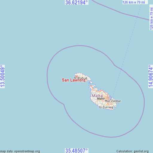
San Lawrenz GPS coordinates[2]
36° 3' 20.016" North, 14° 12' 12.996" East
| Map corner | latitude | longitude |
|---|---|---|
| Upper-left | 36.62194°, | 13.50049° |
| Center: | 36.05556°, | 14.20361° |
| Lower-right: | 35.48507°, | 14.90674° |
| Map W x H: | 126.4×126.4 km | = 78.5×78.5mi |
| max Lat: | 36.07222° ⇑5.6% North |
| San Lawrenz: | 36.05556° |
| min Lat: | ⇓94.4% South 35.82583° |
| min Long | San Lawrenz | max Long |
| 14.20361° | 14.20361° | 14.56701° |
| W 0%⇐ | ⇒100% E |
Elevation
Elevation of San Lawrenz is 131 m = 430 ft, and this is 52.9 m = 174 ft above average elevation for this country.
| Max E: |
231 m = 758 ft | 11.3% |
| San Lawrenz | 131 m 430 ft | |
| Avg. | 78.1 m = 256 ft | |
Min E: |
5 m = 16 ft | 88.7% |
See also: Malta elevation on elevation.city.
Geographical zone
San Lawrenz is located in North temperate zone (between Tropic of Cancer and the Arctic Circle). Distance of this Northern Tropic circle is 1403.1 km =871.8 mi to South.| Distance of | km | miles | from San Lawrenz |
|---|---|---|---|
| North Pole | 5998.1 | 3727 | to North |
| Arctic Circle | 3392.2 | 2107.8 | to North |
| Tropic Cancer | 1403.1 | 871.8 | to South |
| Equator | 4009 | 2491.1 | to South |


Nearby cities:
15 places around San Lawrenz: (largest is in red/bold)
• Fontana
3.5 km =2.2 mi,  124°
124°
• Għajnsielem
8 km =5 mi,  113°
113°
• Għammar
1.8 km =1.1 mi,  48°
48°
• Għarb
0.7 km =0.4 mi,  43°
43°
• Għasri
2.1 km =1.3 mi,  83°
83°
• Kerċem
2.6 km =1.6 mi,  126°
126°
• Munxar
3.9 km =2.4 mi,  136°
136°
• Mġarr
8.9 km =5.5 mi, 112°
• Nadur
8.4 km =5.2 mi,  103°
103°
• Saint Lucia
1.9 km =1.2 mi, 138°
• Sannat
4.9 km =3 mi, 134°
• Victoria
3.5 km =2.2 mi, 110°
• Xagħra
5.5 km =3.4 mi, 96°
• Xewkija
5.5 km =3.4 mi, 117°
• Żebbuġ
3.4 km =2.1 mi,  57°
57°
Sources, notices
• [Note1] Compared only with cities in Malta existing in our database
• [Src1] Map data: © OpenStreetMap contributors (CC-BY-SA)
• [Src2] Other city data from geonames.org with taken over terms of usage.
• [Src3] Geographical zone / Annual Mean Temperature by Robert A. Rohde @ Wikipedia
