Qala geodata
Qala (Il-Qala) is a populated place; located in Malta in Europe/Malta (GMT+2) time zone. With population of 1,534 people, there are 62 cities with bigger population in this country. Compared to other cities in Malta, 84.5% of cities are located further ↓South; 77.5% of cities are located further →East and 78.9% of cities have lower elevation than Qala. Note1


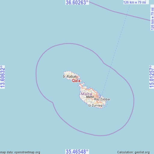
Qala GPS coordinates[2]
36° 2' 9.996" North, 14° 18' 33.984" East
| Map corner | latitude | longitude |
|---|---|---|
| Upper-left | 36.60263°, | 13.60632° |
| Center: | 36.03611°, | 14.30944° |
| Lower-right: | 35.46548°, | 15.01257° |
| Map W x H: | 126.4×126.4 km | = 78.5×78.5mi |
| max Lat: | 36.07222° ⇑15.5% North |
| Qala: | 36.03611° |
| min Lat: | ⇓84.5% South 35.82583° |
| min Long | Qala | max Long |
| 14.20361° | 14.30944° | 14.56701° |
| W 22.5%⇐ | ⇒77.5% E |
Elevation
Elevation of Qala is 112 m = 367 ft, and this is 33.9 m = 111 ft above average elevation for this country.
| Max E: |
231 m = 758 ft | 21.1% |
| Qala | 112 m 367 ft | |
| Avg. | 78.1 m = 256 ft | |
Min E: |
5 m = 16 ft | 78.9% |
See also: Malta elevation on elevation.city.
Geographical zone
Qala is located in North temperate zone (between Tropic of Cancer and the Arctic Circle). Distance of this Northern Tropic circle is 1400.9 km =870.5 mi to South.| Distance of | km | miles | from Qala |
|---|---|---|---|
| North Pole | 6000.2 | 3728.4 | to North |
| Arctic Circle | 3394.3 | 2109.1 | to North |
| Tropic Cancer | 1400.9 | 870.5 | to South |
| Equator | 4006.8 | 2489.7 | to South |


Nearby cities:
15 places around Qala: (largest is in red/bold)
• Fontana
6.6 km =4.1 mi,  271°
271°
• Għajnsielem
2.4 km =1.5 mi,  243°
243°
• Għammar
8.8 km =5.5 mi,  292°
292°
• Għarb
9.4 km =5.8 mi, 286°
• Għasri
7.8 km =4.8 mi, 287°
• Kerċem
7.5 km =4.7 mi, 274°
• Munxar
6.9 km =4.3 mi,  264°
264°
• Mġarr
1.8 km =1.1 mi,  227°
227°
• Nadur
1.4 km =0.9 mi,  277°
277°
• Saint Lucia
8.3 km =5.2 mi, 275°
• Sannat
6.1 km =3.8 mi, 257°
• Victoria
6.3 km =3.9 mi, 278°
• Xagħra
4.3 km =2.7 mi, 290°
• Xewkija
4.6 km =2.9 mi, 265°
• Żebbuġ
7.7 km =4.8 mi,  301°
301°
Sources, notices
• [Note1] Compared only with cities in Malta existing in our database
• [Src1] Map data: © OpenStreetMap contributors (CC-BY-SA)
• [Src2] Other city data from geonames.org with taken over terms of usage.
• [Src3] Geographical zone / Annual Mean Temperature by Robert A. Rohde @ Wikipedia
