Quatre Bornes geodata
Quatre Bornes (Plaines Wilhems) is a populated place; located in Mauritius in Indian/Mauritius (GMT+4) time zone. With population of 80,961 people, there are 4 cities with bigger population in this country. Compared to other cities in Mauritius, 62.6% of cities are located further ↑North; 84.8% of cities are located further →East and 84.8% of cities have lower elevation than Quatre Bornes. Note1


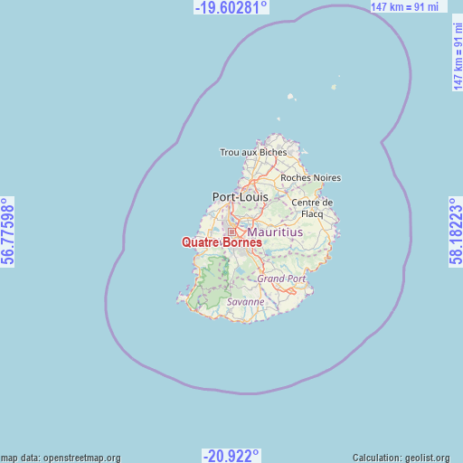
Quatre Bornes GPS coordinates[2]
20° 15' 49.716" South, 57° 28' 44.76" East
| Map corner | latitude | longitude |
|---|---|---|
| Upper-left | -19.60281°, | 56.77598° |
| Center: | -20.26381°, | 57.4791° |
| Lower-right: | -20.922°, | 58.18223° |
| Map W x H: | 146.7×146.7 km | = 91.2×91.2mi |
| max Lat: | -10.38803° ⇑62.6% North |
| Quatre Bornes: | -20.26381° |
| min Lat: | ⇓37.4% South -20.51667° |
| min Long | Quatre Bornes | max Long |
| 56.61795° | 57.4791° | 63.41667° |
| W 15.2%⇐ | ⇒84.8% E |
Elevation
Elevation of Quatre Bornes is 335 m = 1099 ft, and this is 182.9 m = 600 ft above average elevation for this country.
| Max E: |
467 m = 1532 ft | 15.2% |
| Quatre Bornes | 335 m 1099 ft | |
| Avg. | 152.1 m = 499 ft | |
Min E: |
1 m = 3 ft | 84.8% |
See also: Quatre Bornes elevation on elevation.city.
Geographical zone
Quatre Bornes is located in South Torrid zone (between Equator and Tropic of Capricorn). Distance of this Southern Tropic circle is 352.8 km =219.2 mi to South.| Distance of | km | miles | from Quatre Bornes |
|---|---|---|---|
| Equator | 2253.1 | 1400 | to North |
| Tropic Capricorn | 352.8 | 219.2 | to South |
| Antarctic Circle | 5148 | 3198.8 | to South |
| South Pole | 7753.9 | 4818 | to South |


Nearby cities:
15 places around Quatre Bornes: (largest is in red/bold)
• Albion
9.7 km =6 mi,  309°
309°
• Bambous
7.7 km =4.8 mi,  275°
275°
• Beau Bassin-Rose Hill
3.7 km =2.3 mi,  338°
338°
• Cascavelle
7.9 km =4.9 mi,  251°
251°
• Curepipe
7.6 km =4.7 mi,  140°
140°
• Dagotière
8.9 km =5.5 mi,  76°
76°
• Ebene
2.5 km =1.6 mi,  31°
31°
• Gros Cailloux
8.1 km =5 mi,  320°
320°
• Midlands
11.3 km =7 mi,  122°
122°
• Moka
5.3 km =3.3 mi,  19°
19°
• Pailles
8 km =5 mi,  6°
6°
• Petite Rivière
8.3 km =5.2 mi, 335°
• Saint Pierre
6.7 km =4.2 mi,  40°
40°
• Vacoas
3.8 km =2.4 mi,  181°
181°
• Verdun
8.6 km =5.3 mi,  67°
67°
Sources, notices
• [Note1] Compared only with cities in Mauritius existing in our database
• [Src1] Map data: © OpenStreetMap contributors (CC-BY-SA)
• [Src2] Other city data from geonames.org with taken over terms of usage.
• [Src3] Geographical zone / Annual Mean Temperature by Robert A. Rohde @ Wikipedia
