Dagotière geodata
Dagotière (Moka) is a populated place; located in Mauritius in Indian/Mauritius (GMT+4) time zone. With population of 6,915 people, there are 37 cities with bigger population in this country. Compared to other cities in Mauritius, 57.6% of cities are located further ↑North; 62.6% of cities are located further →East and 98% of cities have lower elevation than Dagotière. Note1


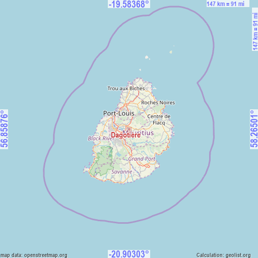
Dagotière GPS coordinates[2]
20° 14' 41.136" South, 57° 33' 42.768" East
| Map corner | latitude | longitude |
|---|---|---|
| Upper-left | -19.58368°, | 56.85876° |
| Center: | -20.24476°, | 57.56188° |
| Lower-right: | -20.90303°, | 58.26501° |
| Map W x H: | 146.7×146.7 km | = 91.2×91.2mi |
| max Lat: | -10.38803° ⇑57.6% North |
| Dagotière: | -20.24476° |
| min Lat: | ⇓42.4% South -20.51667° |
| min Long | Dagotière | max Long |
| 56.61795° | 57.56188° | 63.41667° |
| W 37.4%⇐ | ⇒62.6% E |
Elevation
Elevation of Dagotière is 446 m = 1463 ft, and this is 293.9 m = 964 ft above average elevation for this country.
| Max E: |
467 m = 1532 ft | 2% |
| Dagotière | 446 m 1463 ft | |
| Avg. | 152.1 m = 499 ft | |
Min E: |
1 m = 3 ft | 98% |
See also: Mauritius elevation on elevation.city.
Geographical zone
Dagotière is located in South Torrid zone (between Equator and Tropic of Capricorn). Distance of this Southern Tropic circle is 354.9 km =220.5 mi to South.| Distance of | km | miles | from Dagotière |
|---|---|---|---|
| Equator | 2251 | 1398.7 | to North |
| Tropic Capricorn | 354.9 | 220.5 | to South |
| Antarctic Circle | 5150.2 | 3200.2 | to South |
| South Pole | 7756.1 | 4819.4 | to South |


Nearby cities:
15 places around Dagotière: (largest is in red/bold)
• Camp Thorel
6.6 km =4.1 mi,  59°
59°
• Crève Coeur
6 km =3.7 mi,  355°
355°
• Curepipe
8.8 km =5.5 mi,  205°
205°
• Dubreuil
7.4 km =4.6 mi,  148°
148°
• Ebene
7.3 km =4.5 mi,  269°
269°
• Melrose
7.8 km =4.8 mi,  110°
110°
• Midlands
8.3 km =5.2 mi,  174°
174°
• Moka
7.5 km =4.7 mi,  292°
292°
• Pailles
9.6 km =6 mi,  306°
306°
• Providence
5.3 km =3.3 mi,  89°
89°
• Quartier Militaire
3.7 km =2.3 mi,  95°
95°
• Quatre Bornes
8.9 km =5.5 mi,  256°
256°
• Saint Julien
8 km =5 mi,  75°
75°
• Saint Pierre
5.2 km =3.2 mi, 305°
• Verdun
1.4 km =0.9 mi,  327°
327°
Sources, notices
• [Note1] Compared only with cities in Mauritius existing in our database
• [Src1] Map data: © OpenStreetMap contributors (CC-BY-SA)
• [Src2] Other city data from geonames.org with taken over terms of usage.
• [Src3] Geographical zone / Annual Mean Temperature by Robert A. Rohde @ Wikipedia
