Presidente Cárdenas geodata
Presidente Cárdenas (Tamaulipas) is a populated place; located in Mexico in America/Matamoros (GMT-5) time zone. With population of 553 people, there are 15422 cities with bigger population in this country. Compared to other cities in Mexico, 94.9% of cities are located further ↓South; 66.1% of cities are located further ←West and 92.1% of cities have higher elevation than Presidente Cárdenas. Note1


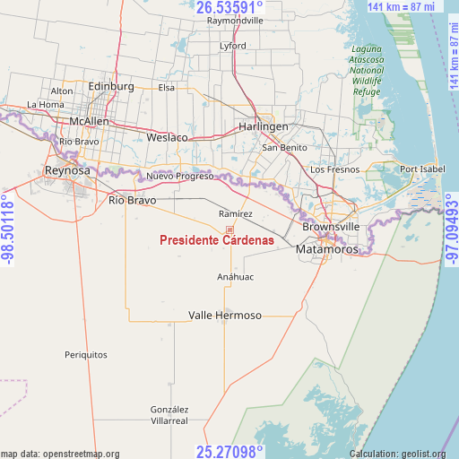
Presidente Cárdenas GPS coordinates[2]
25° 54' 18.504" North, 97° 47' 52.98" West
| Map corner | latitude | longitude |
|---|---|---|
| Upper-left | 26.53591°, | -98.50118° |
| Center: | 25.90514°, | -97.79805° |
| Lower-right: | 25.27098°, | -97.09493° |
| Map W x H: | 140.6×140.6 km | = 87.4×87.4mi |
| max Lat: | 32.7° ⇑5.1% North |
| Presidente Cárdenas: | 25.90514° |
| min Lat: | ⇓94.9% South 14.53588° |
| min Long | Presidente Cár | max Long |
| -117.105° | -97.79805° | -86.73105° |
| W 66.1%⇐ | ⇒33.9% E |
Elevation
Elevation of Presidente Cárdenas is 19 m = 62 ft, and this is 1234.7 m = 4051 ft below average elevation for this country.
| Max E: |
3497 m = 11473 ft | 92.1% |
| Avg. | 1253.7 m = 4113 ft | |
| Presidente Cárdenas | 19 m = 62 ft | |
Min E: |
-1 m = -3 ft | 7.9% |
See also: Mexico elevation on elevation.city.
Geographical zone
Presidente Cárdenas is located in North temperate zone (between Tropic of Cancer and the Arctic Circle). Distance of this Northern Tropic circle is 274.5 km =170.6 mi to South.| Distance of | km | miles | from Presidente Cárdenas |
|---|---|---|---|
| North Pole | 7126.7 | 4428.3 | to North |
| Arctic Circle | 4520.8 | 2809.1 | to North |
| Tropic Cancer | 274.5 | 170.6 | to South |
| Equator | 2880.4 | 1789.8 | to South |


Nearby cities:
15 places around Presidente Cárdenas: (largest is in red/bold)
• Anáhuac
14.5 km =9 mi,  170°
170°
• Brecha 124 con Vía de FFCC
19.6 km =12.2 mi,  299°
299°
• CEFERESO Número 3
17.7 km =11 mi,  111°
111°
• El Control
6.1 km =3.8 mi,  346°
346°
• El Realito
27.8 km =17.3 mi,  196°
196°
• Empalme
1.1 km =0.7 mi,  234°
234°
• Ensenada
8 km =5 mi,  240°
240°
• Guadalupe
21.4 km =13.3 mi,  83°
83°
• Ignacio Manuel Altamirano
2.5 km =1.6 mi, 235°
• La Gloria
18 km =11.2 mi,  100°
100°
• La Venada
24.2 km =15 mi,  121°
121°
• Nuevo Progreso
22.7 km =14.1 mi,  317°
317°
• Ramírez
5.3 km =3.3 mi,  13°
13°
• Santa Adelaida
15.7 km =9.8 mi, 111°
• Valle Hermoso
26 km =16.2 mi,  183°
183°
Sources, notices
• [Note1] Compared only with cities in Mexico existing in our database
• [Src1] Map data: © OpenStreetMap contributors (CC-BY-SA)
• [Src2] Other city data from geonames.org with taken over terms of usage.
• [Src3] Geographical zone / Annual Mean Temperature by Robert A. Rohde @ Wikipedia
