Empalme geodata
Empalme (Tamaulipas) is a populated place; located in Mexico in America/Matamoros (GMT-5) time zone. With population of 778 people, there are 11229 cities with bigger population in this country. Compared to other cities in Mexico, 94.9% of cities are located further ↓South; 66% of cities are located further ←West and 91.2% of cities have higher elevation than Empalme. Note1


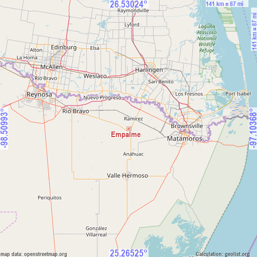
Empalme GPS coordinates[2]
25° 53' 57.984" North, 97° 48' 24.48" West
| Map corner | latitude | longitude |
|---|---|---|
| Upper-left | 26.53024°, | -98.50993° |
| Center: | 25.89944°, | -97.8068° |
| Lower-right: | 25.26525°, | -97.10368° |
| Map W x H: | 140.7×140.7 km | = 87.4×87.4mi |
| max Lat: | 32.7° ⇑5.1% North |
| Empalme: | 25.89944° |
| min Lat: | ⇓94.9% South 14.53588° |
| min Long | Empalme | max Long |
| -117.105° | -97.8068° | -86.73105° |
| W 66%⇐ | ⇒34% E |
Elevation
Elevation of Empalme is 21 m = 69 ft, and this is 1232.7 m = 4044 ft below average elevation for this country.
| Max E: |
3497 m = 11473 ft | 91.2% |
| Avg. | 1253.7 m = 4113 ft | |
| Empalme | 21 m = 69 ft | |
Min E: |
-1 m = -3 ft | 8.8% |
See also: Mexico elevation on elevation.city.
Geographical zone
Empalme is located in North temperate zone (between Tropic of Cancer and the Arctic Circle). Distance of this Northern Tropic circle is 273.8 km =170.1 mi to South.| Distance of | km | miles | from Empalme |
|---|---|---|---|
| North Pole | 7127.3 | 4428.7 | to North |
| Arctic Circle | 4521.4 | 2809.5 | to North |
| Tropic Cancer | 273.8 | 170.1 | to South |
| Equator | 2879.7 | 1789.4 | to South |


Nearby cities:
15 places around Empalme: (largest is in red/bold)
• Anáhuac
14.1 km =8.8 mi,  166°
166°
• Brecha 124 con Vía de FFCC
19.2 km =11.9 mi,  302°
302°
• CEFERESO Número 3
18.3 km =11.4 mi,  108°
108°
• El Control
6.6 km =4.1 mi,  354°
354°
• El Realito
26.9 km =16.7 mi,  194°
194°
• Ensenada
6.9 km =4.3 mi,  241°
241°
• Guadalupe
22.3 km =13.9 mi,  82°
82°
• Ignacio Manuel Altamirano
1.5 km =0.9 mi, 236°
• La Gloria
18.7 km =11.6 mi,  98°
98°
• La Venada
24.6 km =15.3 mi,  119°
119°
• Nuevo Progreso
22.6 km =14 mi,  320°
320°
• Presidente Cárdenas
1.1 km =0.7 mi,  54°
54°
• Ramírez
6.2 km =3.9 mi,  20°
20°
• Santa Adelaida
16.3 km =10.1 mi, 108°
• Valle Hermoso
25.3 km =15.7 mi,  181°
181°
Sources, notices
• [Note1] Compared only with cities in Mexico existing in our database
• [Src1] Map data: © OpenStreetMap contributors (CC-BY-SA)
• [Src2] Other city data from geonames.org with taken over terms of usage.
• [Src3] Geographical zone / Annual Mean Temperature by Robert A. Rohde @ Wikipedia
