Yecapixtla geodata
Yecapixtla (Morelos) is a populated place; located in Mexico in America/Mexico_City (GMT-6) time zone. With population of 16,811 people, there are 569 cities with bigger population in this country. Compared to other cities in Mexico, 67.4% of cities are located further ↑North; 52.5% of cities are located further ←West and 55.1% of cities have lower elevation than Yecapixtla. Note1


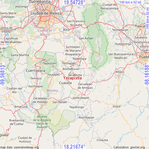
Yecapixtla GPS coordinates[2]
18° 52' 59.988" North, 98° 51' 54" West
| Map corner | latitude | longitude |
|---|---|---|
| Upper-left | 19.54728°, | -99.56813° |
| Center: | 18.88333°, | -98.865° |
| Lower-right: | 18.21674°, | -98.16188° |
| Map W x H: | 147.9×147.9 km | = 91.9×91.9mi |
| max Lat: | 32.7° ⇑67.4% North |
| Yecapixtla: | 18.88333° |
| min Lat: | ⇓32.6% South 14.53588° |
| min Long | Yecapixtla | max Long |
| -117.105° | -98.865° | -86.73105° |
| W 52.5%⇐ | ⇒47.5% E |
Elevation
Elevation of Yecapixtla is 1590 m = 5217 ft, and this is 336.3 m = 1103 ft above average elevation for this country.
| Max E: |
3497 m = 11473 ft | 44.9% |
| Yecapixtla | 1590 m 5217 ft | |
| Avg. | 1253.7 m = 4113 ft | |
Min E: |
-1 m = -3 ft | 55.1% |
See also: Mexico elevation on elevation.city.
Geographical zone
Yecapixtla is located in North Torrid zone (between Equator and Tropic of Cancer). Distance of this Northern Tropic circle is 506.3 km =314.6 mi to North.| Distance of | km | miles | from Yecapixtla |
|---|---|---|---|
| North Pole | 7907.4 | 4913.4 | to North |
| Arctic Circle | 5301.5 | 3294.2 | to North |
| Tropic Cancer | 506.3 | 314.6 | to North |
| Equator | 2099.6 | 1304.6 | to South |


Nearby cities:
15 places around Yecapixtla: (largest is in red/bold)
• Achichipico
8.3 km =5.2 mi,  29°
29°
• Atlatlahucan
6.6 km =4.1 mi,  328°
328°
• Colonia Kilómetro 88
5.5 km =3.4 mi, 334°
• Colonia San Francisco
4.3 km =2.7 mi,  289°
289°
• Huexca
8.8 km =5.5 mi,  183°
183°
• Las Minas
7.1 km =4.4 mi,  277°
277°
• Loma Bonita
9.4 km =5.8 mi,  214°
214°
• Mixtlalcingo
9.6 km =6 mi,  202°
202°
• Rancho Cuachixolotera
9.4 km =5.8 mi, 275°
• San Juan Texcalpan
8.9 km =5.5 mi,  310°
310°
• Texcala
9.3 km =5.8 mi,  52°
52°
• Tierra Larga (Campo Nuevo)
9 km =5.6 mi,  256°
256°
• Tlaltetelco (San Miguel Tlaltetelco)
8 km =5 mi,  342°
342°
• Xochitlán
5.6 km =3.5 mi,  83°
83°
• Yecapixteca
4 km =2.5 mi,  268°
268°
Sources, notices
• [Note1] Compared only with cities in Mexico existing in our database
• [Src1] Map data: © OpenStreetMap contributors (CC-BY-SA)
• [Src2] Other city data from geonames.org with taken over terms of usage.
• [Src3] Geographical zone / Annual Mean Temperature by Robert A. Rohde @ Wikipedia
