Villa Aldama geodata
Villa Aldama (Veracruz) is a populated place; located in Mexico in America/Mexico_City (GMT-6) time zone. With population of 3,291 people, there are 2759 cities with bigger population in this country. Compared to other cities in Mexico, 50.9% of cities are located further ↑North; 72.2% of cities are located further ←West and 90.1% of cities have lower elevation than Villa Aldama. Note1


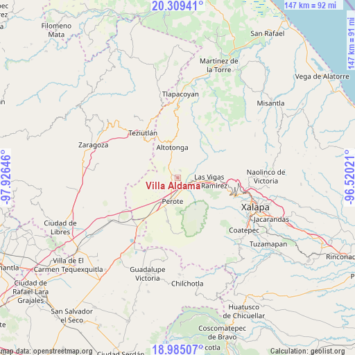
Villa Aldama GPS coordinates[2]
19° 38' 54.996" North, 97° 13' 23.988" West
| Map corner | latitude | longitude |
|---|---|---|
| Upper-left | 20.30941°, | -97.92646° |
| Center: | 19.64861°, | -97.22333° |
| Lower-right: | 18.98507°, | -96.52021° |
| Map W x H: | 147.3×147.3 km | = 91.5×91.5mi |
| max Lat: | 32.7° ⇑50.9% North |
| Villa Aldama: | 19.64861° |
| min Lat: | ⇓49.1% South 14.53588° |
| min Long | Villa Aldama | max Long |
| -117.105° | -97.22333° | -86.73105° |
| W 72.2%⇐ | ⇒27.8% E |
Elevation
Elevation of Villa Aldama is 2409 m = 7904 ft, and this is 1155.3 m = 3790 ft above average elevation for this country.
| Max E: |
3497 m = 11473 ft | 9.9% |
| Villa Aldama | 2409 m 7904 ft | |
| Avg. | 1253.7 m = 4113 ft | |
Min E: |
-1 m = -3 ft | 90.1% |
See also: Mexico elevation on elevation.city.
Geographical zone
Villa Aldama is located in North Torrid zone (between Equator and Tropic of Cancer). Distance of this Northern Tropic circle is 421.2 km =261.7 mi to North.| Distance of | km | miles | from Villa Aldama |
|---|---|---|---|
| North Pole | 7822.3 | 4860.6 | to North |
| Arctic Circle | 5216.5 | 3241.4 | to North |
| Tropic Cancer | 421.2 | 261.7 | to North |
| Equator | 2184.7 | 1357.5 | to South |


Nearby cities:
15 places around Villa Aldama: (largest is in red/bold)
• Centro de Readaptación Social
2.6 km =1.6 mi,  173°
173°
• Cerro de León
2.6 km =1.6 mi,  143°
143°
• Colonia Benito Juárez
7.7 km =4.8 mi,  113°
113°
• Colonia Libertad
3.4 km =2.1 mi,  19°
19°
• Cruz Blanca
6 km =3.7 mi,  101°
101°
• Estanzuela
6 km =3.7 mi,  329°
329°
• Gutiérrez Zamora
8.4 km =5.2 mi,  5°
5°
• Ignacio Zaragoza
7.1 km =4.4 mi,  358°
358°
• Lerdo de Tejada
4.7 km =2.9 mi,  335°
335°
• Los Molinos
6 km =3.7 mi, 171°
• Magueyitos
2.5 km =1.6 mi,  273°
273°
• Mixquiapan
8.2 km =5.1 mi,  315°
315°
• Orilla del Monte
7.4 km =4.6 mi,  280°
280°
• Sierra de Agua
5.4 km =3.4 mi,  153°
153°
• Tepiolulco
7.9 km =4.9 mi, 344°
Sources, notices
• [Note1] Compared only with cities in Mexico existing in our database
• [Src1] Map data: © OpenStreetMap contributors (CC-BY-SA)
• [Src2] Other city data from geonames.org with taken over terms of usage.
• [Src3] Geographical zone / Annual Mean Temperature by Robert A. Rohde @ Wikipedia
