San José Toxi geodata
San José Toxi (State of Mexico) is a populated place; located in Mexico in America/Mexico_City (GMT-6) time zone. With population of 1,735 people, there are 5000 cities with bigger population in this country. Compared to other cities in Mexico, 54.4% of cities are located further ↓South; 63.1% of cities are located further →East and 92.3% of cities have lower elevation than San José Toxi. Note1


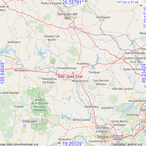
San José Toxi GPS coordinates[2]
19° 52' 4.908" North, 99° 56' 14.496" West
| Map corner | latitude | longitude |
|---|---|---|
| Upper-left | 20.52791°, | -100.64049° |
| Center: | 19.86803°, | -99.93736° |
| Lower-right: | 19.20539°, | -99.23424° |
| Map W x H: | 147.1×147.1 km | = 91.4×91.4mi |
| max Lat: | 32.7° ⇑45.6% North |
| San José Toxi: | 19.86803° |
| min Lat: | ⇓54.4% South 14.53588° |
| min Long | San José Toxi | max Long |
| -117.105° | -99.93736° | -86.73105° |
| W 36.9%⇐ | ⇒63.1% E |
Elevation
Elevation of San José Toxi is 2496 m = 8189 ft, and this is 1242.3 m = 4076 ft above average elevation for this country.
| Max E: |
3497 m = 11473 ft | 7.7% |
| San José Toxi | 2496 m 8189 ft | |
| Avg. | 1253.7 m = 4113 ft | |
Min E: |
-1 m = -3 ft | 92.3% |
See also: Mexico elevation on elevation.city.
Geographical zone
San José Toxi is located in North Torrid zone (between Equator and Tropic of Cancer). Distance of this Northern Tropic circle is 396.8 km =246.6 mi to North.| Distance of | km | miles | from San José Toxi |
|---|---|---|---|
| North Pole | 7797.9 | 4845.4 | to North |
| Arctic Circle | 5192.1 | 3226.2 | to North |
| Tropic Cancer | 396.8 | 246.6 | to North |
| Equator | 2209.1 | 1372.7 | to South |


Nearby cities:
15 places around San José Toxi: (largest is in red/bold)
• Bobashi de Guadalupe
2.8 km =1.7 mi,  72°
72°
• Chosto de los Jarros
2.9 km =1.8 mi,  100°
100°
• La Loma de San Mateo
5.3 km =3.3 mi,  32°
32°
• La Mesa de Chosto
5.2 km =3.2 mi,  109°
109°
• Los Pastores (Pastores Segundo Barrio)
4.8 km =3 mi,  254°
254°
• Manto del Río Ejido
3.3 km =2.1 mi,  161°
161°
• Pastores Primer Barrio
5.5 km =3.4 mi,  256°
256°
• San Bartolo Lanzados
4.5 km =2.8 mi,  92°
92°
• San Francisco Tepeolulco
6.6 km =4.1 mi,  233°
233°
• San Jerónimo de los Jarros
1.9 km =1.2 mi,  51°
51°
• San Juan de los Jarros
2.3 km =1.4 mi, 106°
• San Mateo el Viejo
5.9 km =3.7 mi, 28°
• San Pedro el Alto
5.5 km =3.4 mi,  329°
329°
• Santa Lucía (Ejido de San Mateo el Viejo)
4.5 km =2.8 mi,  44°
44°
• Santo Domingo Shomege (Shomege)
4.5 km =2.8 mi,  124°
124°
Sources, notices
• [Note1] Compared only with cities in Mexico existing in our database
• [Src1] Map data: © OpenStreetMap contributors (CC-BY-SA)
• [Src2] Other city data from geonames.org with taken over terms of usage.
• [Src3] Geographical zone / Annual Mean Temperature by Robert A. Rohde @ Wikipedia
