Toluca geodata
Toluca (State of Mexico) is a seat of a first-order administrative division; located in Mexico in America/Mexico_City (GMT-6) time zone. With population of 489,333 people, there are 37 cities with bigger population in this country. Compared to other cities in Mexico, 59.1% of cities are located further ↑North; 59.5% of cities are located further →East and 96.9% of cities have lower elevation than Toluca. Note1


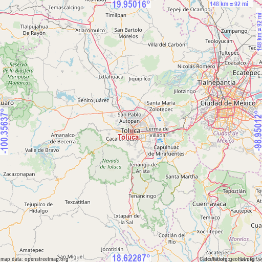
Toluca GPS coordinates[2]
19° 17' 16.296" North, 99° 39' 11.664" West
| Map corner | latitude | longitude |
|---|---|---|
| Upper-left | 19.95016°, | -100.35637° |
| Center: | 19.28786°, | -99.65324° |
| Lower-right: | 18.62287°, | -98.95012° |
| Map W x H: | 147.6×147.6 km | = 91.7×91.7mi |
| max Lat: | 32.7° ⇑59.1% North |
| Toluca: | 19.28786° |
| min Lat: | ⇓40.9% South 14.53588° |
| min Long | Toluca | max Long |
| -117.105° | -99.65324° | -86.73105° |
| W 40.5%⇐ | ⇒59.5% E |
Elevation
Elevation of Toluca is 2671 m = 8763 ft, and this is 1417.3 m = 4650 ft above average elevation for this country.
| Max E: |
3497 m = 11473 ft | 3.1% |
| Toluca | 2671 m 8763 ft | |
| Avg. | 1253.7 m = 4113 ft | |
Min E: |
-1 m = -3 ft | 96.9% |
See also: Toluca elevation on elevation.city.
Geographical zone
Toluca is located in North Torrid zone (between Equator and Tropic of Cancer). Distance of this Northern Tropic circle is 461.3 km =286.6 mi to North.| Distance of | km | miles | from Toluca |
|---|---|---|---|
| North Pole | 7862.5 | 4885.5 | to North |
| Arctic Circle | 5256.6 | 3266.3 | to North |
| Tropic Cancer | 461.3 | 286.6 | to North |
| Equator | 2144.6 | 1332.6 | to South |


Nearby cities:
15 places around Toluca: (largest is in red/bold)
• Barrio de la Cruz
4.2 km =2.6 mi,  186°
186°
• Barrio la Venta
5.5 km =3.4 mi,  160°
160°
• Calixtlahuaca
6.6 km =4.1 mi,  325°
325°
• Colonia Loma Bonita
6.2 km =3.9 mi, 185°
• La Planada (El Arenal)
5.6 km =3.5 mi, 333°
• Los Rosales
6.4 km =4 mi,  252°
252°
• Metepec
6.3 km =3.9 mi,  120°
120°
• San Buenaventura
3.2 km =2 mi,  220°
220°
• San Felipe Tlalmimilolpan
5.5 km =3.4 mi,  167°
167°
• San Francisco Cuaxusco
4.2 km =2.6 mi, 122°
• San Jerónimo Chicahualco
6.4 km =4 mi,  95°
95°
• San Jorge Pueblo Nuevo
4.6 km =2.9 mi,  144°
144°
• San Marcos Yachihuacaltepec
4.8 km =3 mi, 325°
• Santa María Magdalena Ocotitlán
6.4 km =4 mi,  151°
151°
• Santa María Totoltepec
6.7 km =4.2 mi,  71°
71°
Sources, notices
• [Note1] Compared only with cities in Mexico existing in our database
• [Src1] Map data: © OpenStreetMap contributors (CC-BY-SA)
• [Src2] Other city data from geonames.org with taken over terms of usage.
• [Src3] Geographical zone / Annual Mean Temperature by Robert A. Rohde @ Wikipedia
